WPC MPD 6
Published 2 months ago• 3 minute read
WPC Met Watch
Mesoscale Precipitation Discussion: #0006 (Issued at 1243 AM EST Thu Jan 30 2025 )
MPD Selection

Last Updated: 1243 AM EST Thu Jan 30 2025
Mesoscale Precipitation Discussion: #0006 (Issued at 1243 AM EST Thu Jan 30 2025 )
MPD Selection

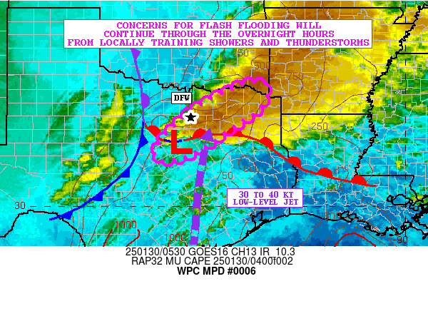
Mesoscale Precipitation Discussion 0006 NWS Weather Prediction Center College Park MD 1243 AM EST Thu Jan 30 2025 Areas affected...North-Central to Northeast TX...Far Southeast OK Concerning...Heavy rainfall...Flash flooding likely Valid 300543Z - 301043Z SUMMARY...Heavy showers and thunderstorms will continue through the overnight hours. Areas of cell-training will continue to pose concerns for flash flooding and especially around the more urbanized locations. This will include the Dallas-Fort Worth metropolitan area. DISCUSSION...The latest GOES-E IR satellite imagery in conjunction with dual-pol radar shows a southwest/northeast oriented band of heavy showers and thunderstorms impacting areas of north-central to northeast TX, including especially the southern and eastern portions of the Dallas-Fort Worth (DFW) metropolitan area. All of the convection is being driven by the interaction of shortwave energy ejecting northeast across the southern Plains out ahead of the deep closed low over the Southwest, and with the pooling of at least modest instability and favorable southerly moisture transport out ahead of a frontal zone. MUCAPE values across much of central to northeast TX have risen to as much as 1000 J/kg with the aid of a southerly low-level jet of 30 to 40+ kts, and the CIRA-LVT values in the SFC-850 mb layer have been increasing steadily over the last few hours which is reflective of the increasing low-level moisture transport. The flow aloft is quite divergent based off the GOES-E IR/WV data and this should continue to promote a stronger low-level jet response going through the overnight hours with enhanced warm air advection along with favorable moisture and instability transport for heavy rainfall. There has been some cell-training noted with the convection over the last couple of hours and portions of the DFW metroplex have already received 2 to 3+ inches of rain with rainfall rates with some of the stronger cells reaching 1.5+ inches/hour. Over the next few hours, the focus for the strongest axis of convection and heavy rainfall should tend to remain over the southern and eastern sides of the broader DFW metroplex, with some localized expansion of convection expected off to the northeast toward areas of the Arklatex, but mainly concentrated over areas of northeast TX and far southeast OK. Additional rainfall amounts of 2 to 4 inches are forecast overnight with isolated heavier totals possible where any cell-training tends to persist. Given the heavy rainfall that has already occurred over the last few hours, and these additional totals, flash flooding is likely overnight with the more urban locations the most susceptible to impacts. Orrison ATTN...WFO...FWD...SHV...TSA... ATTN...RFC...ABRFC...LMRFC...WGRFC...NWC... LAT...LON 33999460 33289472 32549572 31759694 31499786 31699820 32269791 33179691 33949544Download in GIS format: Shapefile | KML
Recommended Articles
You may also like...
Loading...


