Isolated showers possible as Maryland gets relief from hot weather through Saturday - CBS Baltimore
/ CBS Baltimore
CBS News Live
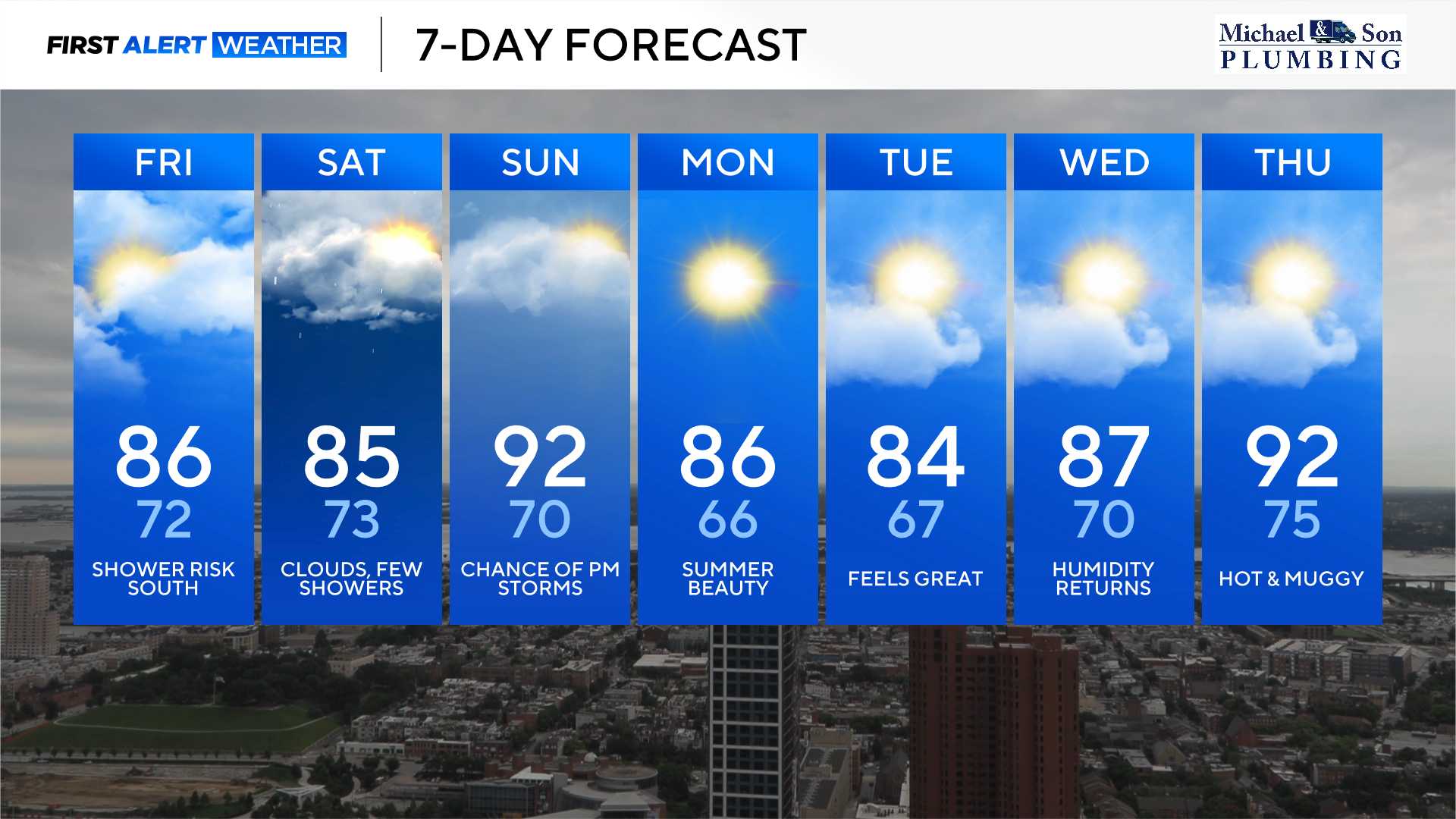
Maryland will get some relief from the hot weather through Saturday, but humidity will still be moderately high.
We could see clouds linger into Saturday, with a few isolated to widely scattered showers. Most of the weekend looks rain-free despite some chances.
A weak cold front has pushed south of the area, and that has brought in some much-welcomed relief from the intense heat Friday into Saturday.
Expect mostly cloudy skies with moderate to high levels of humidity. The highest humidity levels will remain across central and southern Maryland with more of a break from the humidity across northeastern Maryland.
There is the possibility of a stray shower south of Baltimore City today. A better chance of isolated to widely scattered showers and storms tonight into Saturday as the boundary slowly lifts back to the north.
High temperatures today and Saturday will be in the middle to upper 80s in and around the Baltimore metro. Northeastern Maryland will see highs in the lower to middle 80s.
While humidity levels will drop across northeastern Maryland today, very tropical humidity will return across the area tonight and spread across the entire state of Maryland Saturday. Fortunately, clouds will limit how hot we get Saturday during this stretch of very high humidity.
Heat and humidity briefly return to the area Sunday. Expect a mixture of clouds and sunshine with much higher temperatures. Highs will climb into the lower 90s with heat index values reaching 95° to 100°.
A cold front will approach the area during the afternoon and evening hours, sparking off isolated strong to severe thunderstorms. We are not expecting many thunderstorms to form, but the ones that do have the capability of producing damaging winds, lightning, and heavy downpours.
Any storms should exit by late Sunday evening as skies begin to clear and humidity levels will begin to drop toward sunrise Monday.
Some of the best weather of the entire summer is coming to Maryland Monday through Wednesday of next week. High pressure to our north will push the intense levels of heat and humidity to our south for a few days.
Monday and Tuesday look like the most comfortable days of this stretch with partly to mostly sunny skies, very low humidity, and comfortably warm temperatures. Highs Monday and Tuesday will be in the mid-80s. Overnight lows will even dip into the 60s for some better sleeping weather.
Wednesday will be a transition day as winds veer out of the south, bringing in more muggy air. Even though Wednesday looks more humid, the humidity levels don't look unbearable. Highs will top out in the upper 80s.
Tough heat and humidity will be returning to Maryland late next week into next weekend. Look for tropical levels of humidity with potentially even hotter afternoon high temperatures in the mid-90s. Heat index values will once again climb to above 100°.
In addition to the brutal heat and humidity returning, strong to severe storms may also return to the area, especially during the afternoon and evening hours next Friday through next weekend.