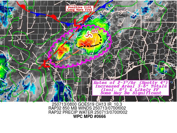
WPC MPD 666
Mesoscale Precipitation Discussion: #0666 (Issued at 417 AM EDT Sun Jul 13 2025 )
MPD Selection

Mesoscale Precipitation Discussion 0666 NWS Weather Prediction Center College Park MD 417 AM EDT Sun Jul 13 2025 Areas affected...Central Texas... Concerning...Heavy rainfall...Flash flooding likely Valid 130815Z - 131415Z SUMMARY...Potential for significant flash flooding likely to continue. Additional 3-6" totals may overlap with ongoing flooding areas but will result in overall areal expansion of additional flash flooding through day break. DISCUSSION...GOES-E WV suite shows a strong/compact center of base of long wave vorticity center over north-central to northeastern OK. A smaller scale shortwave that was noted earlier this evening has sheared/elongated and expanded the positive tilt trough all the through the Lower Pecos River Valley into northern Coahuila. This setup has maintained a surface low along the Rio Grande near KDRT with a surface trof that extends northeast through the southern Hill Country; while the main surface low along the front continues to sag south toward KBKD in Northwest TX, increasing surface to low level response. Additionally, this surface trough has a 5-7 degree Td gradient along it separating moist air, from very moist air with Tds into the mid-70s. Broad orthogonal surface to 700mb has been strongly convergent along the boundary for clusters of elevated storms to develop with increasing moisture flux supporting deep warm cloud processes and efficient rainfall production. Combine this with the elongation of the trof helping to expand the entrance to the northern stream jet across N TX into OK maximizing divergence aloft to help maintain the outflow. The slightly increased confluent flow through the Colorado River Valley nearer the frontal wave, has rapidly matured the convection into a smaller MCS with a solid bowing segment along the upstream edge. Total PWat values in this confluent region have remained elevated compared to further west with totals over 2" approaching 2.25". Given strength of convergence, occasional rates of up to 4" have be estimated with solid 2-3" totals observed across Lampasas county. 500-1000mb thickness and VWP suggest propagation vectors will shift from south to more west-southwest counter to the deeper layer steering flow, allowing for some training/repeating convective cores. Given high likelihood of broader 2-3"/hr rates (with smaller isolated 4" rates), additional 3-6" are probable but a localized maximum of 8" can not be fully ruled out. Further west, strengthening LLJ across the southern Hill Country into the Concho Valley has seen a maturing cluster centered near Schleicher county. Slightly reduced deeper layer moisture may support increased cold pool generation and orientation along the southeastern flank of the MCV/developing 500mb wave, cell motions toward the south and potentially eastward into the cluster is possible and similar 3-6" totals are growing more likely as well. Concern for this cluster to shift eastward and merge with more mature complex could present a worse case evolution, for increased duration to push those isolated additional 8" totals through 15z. Regardless, areal coverage of intense rainfall to induce flash flooding is likely and given placement to the Hill Country, a few locations of significant flash flooding becoming increasing possible. Gallina ATTN...WFO...EWX...FWD...SJT... ATTN...RFC...FWR...NWC... LAT...LON 32639846 32519758 32189690 31659657 31069670 30699714 30389772 29729936 29630074 30280123 31120092 31850015 32279948Download in GIS format: Shapefile | KML
You may also like...
Diddy's Legal Troubles & Racketeering Trial

Music mogul Sean 'Diddy' Combs was acquitted of sex trafficking and racketeering charges but convicted on transportation...
Thomas Partey Faces Rape & Sexual Assault Charges

Former Arsenal midfielder Thomas Partey has been formally charged with multiple counts of rape and sexual assault by UK ...
Nigeria Universities Changes Admission Policies

JAMB has clarified its admission policies, rectifying a student's status, reiterating the necessity of its Central Admis...
Ghana's Economic Reforms & Gold Sector Initiatives

Ghana is undertaking a comprehensive economic overhaul with President John Dramani Mahama's 24-Hour Economy and Accelera...
WAFCON 2024 African Women's Football Tournament

The 2024 Women's Africa Cup of Nations opened with thrilling matches, seeing Nigeria's Super Falcons secure a dominant 3...
Emergence & Dynamics of Nigeria's ADC Coalition

A new opposition coalition, led by the African Democratic Congress (ADC), is emerging to challenge President Bola Ahmed ...
Demise of Olubadan of Ibadanland
Oba Owolabi Olakulehin, the 43rd Olubadan of Ibadanland, has died at 90, concluding a life of distinguished service in t...
Death of Nigerian Goalkeeping Legend Peter Rufai

Nigerian football mourns the death of legendary Super Eagles goalkeeper Peter Rufai, who passed away at 61. Known as 'Do...


