Sunny, seasonable Friday in Philadelphia region before weekend storms. Here's the weather forecast. - CBS Philadelphia
/ CBS Philadelphia
Sunny Friday in Philadelphia region, tracking snow on Sunday during Eagles game
The workweek in the Philadelphia region will end on Friday with sunshine and seasonable highs in the 40s.
As we head into the holiday weekend, here's what the NEXT Weather team is tracking as more storms and snow are on the way.
We are tracking another system on Saturday with rain and snow showers possible during the day. The snow showers will likely be earlier in the day and north of Philly as highs will reach the low 40s. Cold air slides in behind this system, creating an interesting setup for Sunday.
On Sunday, a different disturbance tracks through the Deep South to the Tennessee Valley and off the Carolina coast as a coastal storm. Then it travels north off the Jersey Shore, bringing a good chance of snow showers Sunday afternoon through Sunday night.
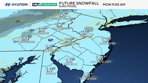
Some accumulation is possible, with the potential for some moderate snow if the system lines up right. Forecast ranges are from a low end of a half of an inch to 1.5 inches to a high end of 5 to 7 inches. It's possible that we may end up in the middle. The NEXT Weather team will be putting out a snow map later on Friday. Both global models are in alignment with this scenario, but changes are still possible.
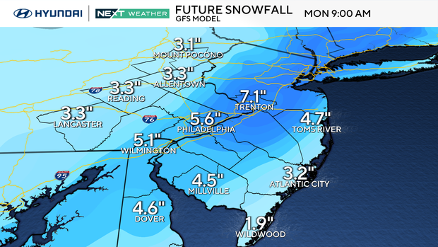
A NEXT Weather Alert will be in effect for Sunday afternoon through Monday morning due to possible snow during travel before and after the Eagles game and the early Monday morning commute, even though it's a holiday.
For Monday, MLK Day snow showers end early and sunshine returns. Temperatures will be frigid in the teens to start the day and only reach the mid-20s. On Monday night, we drop to the single digits in the city and near or below zero in some areas away from the city.
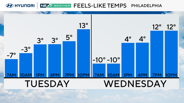
That cold blast on Monday is just the beginning of an Arctic blast that brings the coldest air we have had since 2018. Tuesday's highs will only reach the mid-teens and lows that night will be in the single digits.
Wind chills will dip below zero at times. We remain below freezing 24 hours a day from Sunday evening through late week.
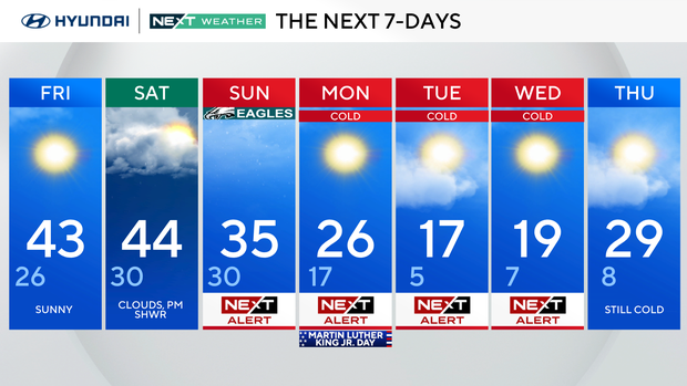
Sunny. High 43, Low 26.
Clouds, PM shower. High 44, Low 30.
NEXT Weather Alert for snow. High 35, Low 30.
NEXT Weather Alert for cold. High 26, Low 17.
NEXT Weather Alert for cold. High 17, Low 5.
NEXT Weather Alert for cold. High 19, Low 7.
Still cold. High 29, Low 8.