Storm threat ends tonight; more storms expected across Maryland Tuesday & Wednesday - CBS Baltimore
/ CBS Baltimore
More storms to hit Maryland on Tuesday
Severe thunderstorms that impacted the region Monday afternoon are moving out, with rain expected to end across all areas by midnight.
As skies begin to clear overnight, patchy fog will be possible. Temperatures will fall into the low to mid-70s.
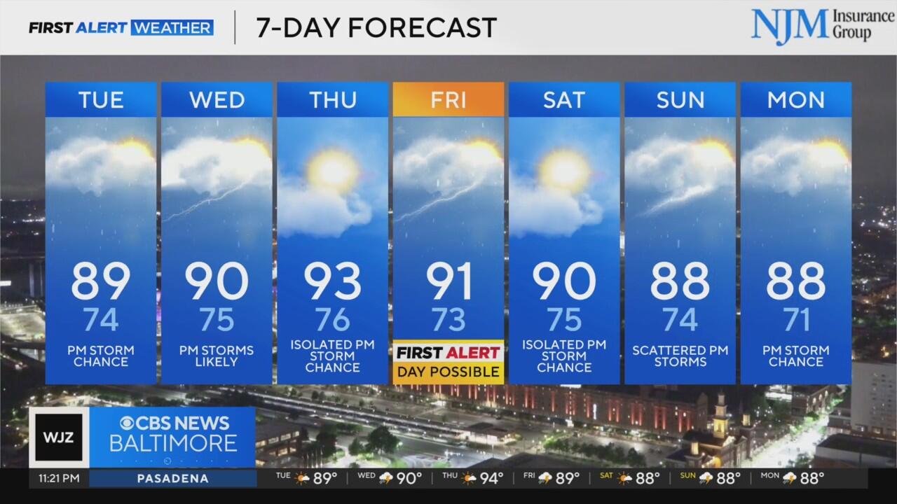
Tuesday will bring a mix of sun and clouds, with hot and humid conditions returning. Afternoon highs will reach around 90 degrees, and heat index values could climb into the upper 90s to near 100. While storm activity will be more isolated compared to the widespread storms seen Sunday and Monday, any storms that do develop may produce torrential rainfall capable of causing isolated flash flooding.
Another upper-level disturbance will approach the region on Wednesday, increasing the coverage of showers and thunderstorms. Some of these storms may become strong to severe, bringing the threat of gusty winds, heavy rainfall, and flash flooding. Highs will once again top out near 90.
A brief lull in storm activity is expected Thursday. Highs will rise into the low 90s with continued high humidity, resulting in heat index values above 100. Storm chances will be isolated during the afternoon.
By Friday, storm chances return and may become more widespread. A First Alert Weather Day is possible due to the potential for severe storms and flooding. Temperatures will climb to near 90 before afternoon storms move in.
The active weather pattern continues into the weekend. Isolated storms are possible Saturday, but a greater threat for storms is expected Sunday. Highs each day will be in the upper 80s to near 90, with overnight lows in the 70s.
Looking ahead to next week, more storm chances are expected, particularly during the afternoon and evening hours.
Derek Beasley joined the WJZ First Alert Weather Team in March 2022. He was promoted in March 2023 to become WJZ's first-ever Chief Meteorologist.