Summer heat in Maryland with strong to severe storms possible - CBS Baltimore
/ CBS Baltimore
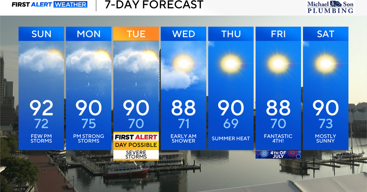
Typical summer heat and humidity will continue across Maryland on this Sunday. Similar to Saturday, isolated to widely scattered strong storms will develop during the afternoon and evening hours, especially areas along and east of I-95.
Expect another round of summertime heat and humidity across Maryland Sunday and Monday. Isolated to widely scattered storms are possible during the afternoon and evening hours each day.
The heat combined with tropical levels of humidity will make temperatures feel like the middle to upper 90s this afternoon with low 100s possible across parts of the eastern shore. Stay hydrated and take plenty of breaks during the heat. The UV index today is a very high 10, so apply sunscreen often and generously.
Isolated to widely scattered thunderstorms are possible later this afternoon and into the early evening hours. The best chance for storms today appears to be near I-95 and points south and east. Any storm that does manage to develop could have localized damaging winds, drenching downpours, and intense lightning. If you're attending the O's game this afternoon, there is the chance of a passing heavy thunderstorm, so don't be surprised if there is a potential rain delay.
Monday will be very similar to Sunday with hot and muggy weather with isolated to scattered storms developing during the afternoon and evening hours. Unlike Sunday, isolated to widely scattered strong to severe storms are possible anywhere across central and eastern Maryland. The strongest storms will deliver isolated pockets of damaging winds, drenching downpours, intense lightning.
Tuesday will be our last hot and very muggy day for awhile. If we do manage to get sunshine during the morning and early afternoon hours, temperatures will soar into the lower to middle 90s. Feels like temperatures will top out in the upper 90s to lower 100s.
Tuesday has been tagged as possible First Alert Weather Day for the possibility of severe storms during the afternoon and evening hours. Tuesday's cold front will be a strong one, and if we receive enough sunshine ahead of it, the storms will likely be strong to severe with a line of storms containing surges of damaging winds, torrential downpours, intense lightning, and hail. Stay with our First Alert Weather Team as an Alert Day is becoming increasing likely and we'll be here to update you on Tuesday's storm potential.
A few early morning showers are possible Wednesday as the cold front slowly works its way offshore. Any showers should clear by mid-morning leaving us with some beautiful weather to follow.
Wednesday afternoon should be very nice with a mixture of sunshine and clouds with falling humidity levels. Highs will top out in the upper 80s. Thursday looks sunny, hot, and quiet with highs near 90°.
Some of the best weather of the summer will be arriving July 4th and continuing through the holiday weekend.
On Friday July 4th, we're forecasting some of the best weather in the next 10-days. Expect plenty of sunshine with comfortable morning temperatures in the middle to upper 70s and cookout temperatures during the afternoon in the middle to upper 80s. Fireworks celebrations should be picture perfect with mostly clear skies and temperatures in the upper 70s to lower 80s.
High pressure should keep our weather quiet, sunny, and very warm for the rest of Independence Day weekend. Highs will be in the lower 90s with plenty of sunshine. Enjoy!