Mystery Solved: Colorado's Destructive Landspout Explained
Learn about landspout tornadoes, a less intense yet genuine form of tornado, distinct from their classic counterparts. This article explains their unique formation process, their appearance as skinny ropes, and why they can pose a threat despite being weaker and shorter-lived.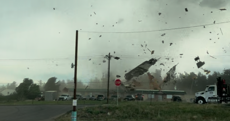
The common perception of a tornado often conjures images from movies like "Twister" or "The Wizard of Oz," depicting powerful, destructive storms spiraling down from massive, rotating thunderstorms, typically accompanied by severe tornado warnings and the potential for widespread damage. However, not all tornadoes conform to this classic formation. Recent weather events across Colorado,for instance, have showcased a different type of phenomenon known as a landspout tornado, which deviates significantly from the typical severe weather outbreak scenario.
A landspout tornado is characterized as a less intense variant of a tornado. Visually, it typically appears as a slender, rope-like column extending from the base of a cloud directly to the ground. While it possesses rotational motion and can quickly pick up dust or debris, it is generally weaker and considerably shorter-lived compared to the more conventional tornadoes associated with mesocyclones. Despite its reduced intensity, it remains a genuine tornado and warrants the same level of caution and respect if observed.

Photo Credit: Wikipedia
The fundamental distinction between landspouts and classic tornadoes lies in their formation mechanism. Traditional, more dangerous tornadoes derive their power from a rotating core called a mesocyclone, which forms within a supercell thunderstorm and produces strong, detectable rotation on radar, thus allowing for timely warnings. In contrast, landspouts typically materialize on hot, dry days under conditions of atmospheric instability, often when ordinary thunderstorms are developing overhead.
Crucially, landspouts lack the foundational rotating core of a mesocyclone. Their formation begins at the surface: low pressure develops, causing air to rush inward and rise. This inward flow increases circulation. As a thunderstorm's updraft develops directly above this nascent circulation, it stretches the column of rising air upwards towards the cloud. This stretching action serves to tighten the rotation, culminating in the formation of the visible landspout tornado. As the landspout intensifies, it can entrain dust and debris from the ground, mimicking the appearance of its more formidable counterparts. The circulation of a landspout is eventually dissipated when it begins to ingest cooler air.
Unlike their mesocyclone-driven cousins, landspouts originate from non-rotating, ordinary thunderstorms, frequently along an outflow boundary or a dryline. Their development is often rapid and occurs very close to the surface, making them particularly challenging to detect with conventional radar systems, as they do not exhibit the distinct warning signatures associated with supercell tornadoes.

Photo Credit: CNN
This inherent lack of early detection was evident with the landspout that formed in Franktown, Colorado, on a recent Monday. This specific event caused damage and appeared with very little advance warning, underscoring the unpredictable nature of these phenomena.
Therefore, even though a landspout is usually weaker, any observed funnel forming should be treated as a legitimate tornado, necessitating immediate safety precautions. This comprehensive understanding of landspout tornadoes, including their unique characteristics and formation processes, is vital for public awareness and safety, especially in regions prone to such atmospheric events.