Flash flooding, strong winds possible during severe weather in Maryland Monday - CBS Baltimore
/ CBS Baltimore
CBS News Live
Severe weather in Maryland Monday afternoon will bring a risk of damaging winds and severe flooding.
Most areas will stay rain-free through lunchtime, but showers and thunderstorms will become numerous and widespread during the afternoon and evening.
Today brings a chance of more widespread showers and thunderstorms across Maryland, especially during the late morning and afternoon hours. Storms will initially develop along the bay breeze around the lunch-hour.
Heavy thunderstorms will become more expansive in coverage during the afternoon hours across much of central and western Maryland. Storms will be slow-moving and capable of torrential rainfall and flash flooding.
Because of recent heavy rains, additional intense rainfall rates, and slow storm movement, there is a level 3 out of 4 threat for flash flooding Monday. More than 2" of rain will fall in less than an hour in a few spots. This could lead to quickly developing street and road flooding, especially during the afternoon and evening commute.
In addition to heavy rain, storms will produce tons of lightning. "When thunder roars, move indoors." A couple storms could also produce strong to damaging wind gusts. This may cause power outages in some neighborhoods. Have, at least, one way to be alerted to flooding and severe weather Monday.
It's a tropical heat today with heat index values ranging between 90° to 100°
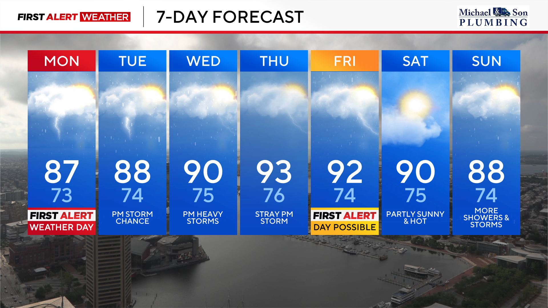
Isolated to widely scattered storms are still possible late Tuesday afternoon into Tuesday evening. Highs will top out in the upper 80s with heat index values in the middle 90s.
While some storms are possible Tuesday, many neighborhoods will get a much needed rain-free day.
Thursday looks extremely hot and humid with highs in the lower to middle 90s. Heat index values Thursday afternoon will top out in the lower 100s. While an isolated shower or thunderstorm is possible Thursday, they should be fairly sparse. Please stay hydrated Thursday and check-in on pets, friends, and family with this upcoming round of heat.
The front responsible for a brief break in the storms on Tuesday will lift north again Wednesday. This will bring more heat, higher humidity, and additional strong to potentially severe thunderstorms Wednesday afternoon and evening. Since the humidity will be so high Wednesday, any downpours will have the capability of more flash flooding. Highs before the storms form Wednesday afternoon will be around 90° with heat index values close to 100°.
A separate slow-moving cold front will approach the area Friday afternoon and evening with additional strong to severe thunderstorms possible. These storms pose the risk of damaging winds along with torrential downpours and more possible flash flooding. Since storms look to be more organized and widespread Friday, our First Alert Weather Team has tagged Friday as a possible First Alert Weather Day.
Saturday appears to be the pick of the weekend with a mixture of clouds and sunshine with highs around 90°. Saturday's rain risk looks much lower with just a stray shower or thunderstorm possible during the afternoon and evening.
Sunday looks to turn stormy again, especially during the afternoon and evening hours as another round of heavy thunderstorms becomes possible. Stay tuned to this forecast as saturated grounds and potential heavy rainfall mean the possibility of more flash flooding.