Already have Rappler+?
to listen to groundbreaking journalism.
This is AI generated summarization, which may have errors. For context, always refer to the full article.

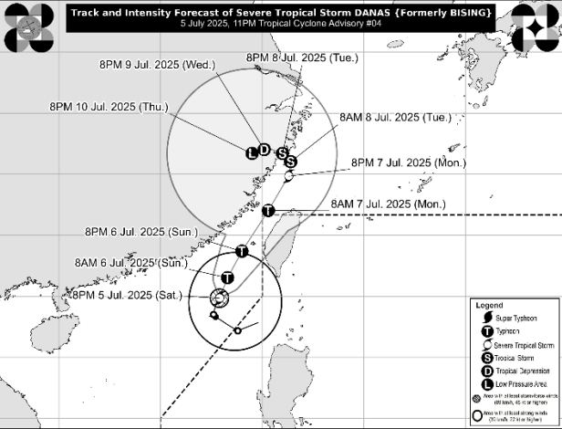
BISING. Satellite image of Typhoon Bising (Danas) outside the Philippine Area of Responsibility as of July 6, 2025, 10 am.
PAGASA
Typhoon Bising (Danas) is still expected to briefly reenter the Philippine Area of Responsibility, possibly on Sunday evening, July 6, or early Monday morning, July 7
MANILA, Philippines – Bising (Danas) strengthened from a severe tropical storm into a typhoon at 8 am on Sunday, July 6, while still lingering right outside the Philippine Area of Responsibility (PAR).
In an advisory issued at 11 am, the Philippine Atmospheric, Geophysical, and Astronomical Services Administration (PAGASA) said Bising now has maximum sustained winds of 120 kilometers per hour from the previous 110 km/h. Its gustiness is now up to 150 km/h from 135 km/h.
The typhoon was last spotted 385 kilometers west northwest of Itbayat, Batanes, at 10 am. It is moving north northeast toward PAR at just 10 km/h.
Batanes and Babuyan Islands still have scattered rain and thunderstorms from the trough or extension of Bising.
PAGASA also issued another gale warning for the northern seaboard of Northern Luzon, particularly Batanes, at 5 am on Sunday. These are the sea conditions in the next 24 hours:
Up to very rough seas (travel is risky for all vessels)
Up to rough seas (small vessels should not venture out to sea)
Up to moderate seas (small vessels should take precautionary measures or avoid sailing, if possible)
ALSO ON RAPPLER
Bising had left PAR at 12 pm on Friday, July 4, around 10 hours after developing. However, it began recurving toward PAR on Saturday, July 5.
In the next 36 hours, or until Monday, July 7, the typhoon is expected to keep moving generally northeast.
It could reenter PAR through the northwestern boundary — where Taiwan is located — on Sunday evening or early Monday morning, but would immediately exit again, according to PAGASA. Taiwan is within PAR.
The weather bureau added that Bising may intensify further within 24 hours, but “a weakening trend is expected over the East China Sea.” It may just be a remnant low by Thursday, July 10, “as it interacts with the landmass of China.”

Bising was the Philippines’ second tropical cyclone for 2025 and the first for the month of July.
PAGASA expects 11 to 19 tropical cyclones to form within or enter PAR in the second half of 2025. These are the weather bureau’s estimates per month:
Meanwhile, PAGASA released a separate advisory for the southwest monsoon or habagat, also at 11 am on Sunday.
Rain due to the southwest monsoon is heaviest in the following provinces located on the western side of Luzon:
Sunday noon, July 6, to Monday noon, July 7
Monday noon, July 7, to Tuesday noon, July 8
Floods and landslides remain possible.
On Sunday, the southwest monsoon is also causing scattered rain and thunderstorms in Metro Manila, Calabarzon, Mimaropa, the Cordillera Administrative Region, the rest of Cagayan Valley, the rest of Central Luzon, Western Visayas, the Negros Island Region, the Zamboanga Peninsula, and the Bangsamoro Autonomous Region in Muslim Mindanao.
The rest of the country will only have isolated rain showers or thunderstorms on Sunday, still due to the southwest monsoon.
How does this make you feel?
Loading