Showers bring day temp closer to that of night in Bhopal | Bhopal News - Times of India
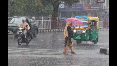
Bhopal: The city witnessed its first spell of proper, widespread showers after the onset of the monsoon on Sunday. The showers during the day sharply dipped the day temperature. The variation between the day temperature and night temperature was barely two degrees.The day temperature in Bhopal on Sunday was recorded at 26.6 degrees Celsius, nine degrees less than the normal mark, while the night temperature in the city was 24.2 degrees Celsius, a degree less than the normal. Between 8:30 am and 5:30 pm, the city recorded 21 mm of rain.In the forecast for Bhopal on Monday, the meteorological dept said there would be a cloudy sky with light to moderate rainfall. Day and night temperatures would be respectively 28 degrees Celsius and 24 degrees Celsius, while the average wind speed will be 22 kilometres per hour.A warning of thunderstorms with lightning and gusty wind was issued for Bhopal, Raisen, Sehore, Narmadapuram, Betul, Harda, Burhanpur, Khandwa, Khargone, Barwani, Alirajpur, Mandsaur, Neemuch, Datia, Bhind, Singrauli, Sidhi, Anuppur, Shahdol, Umaria, Dindori, Katni, Jabalpur, Narsinghpur, Chhindwara, Seoni, Mandla, Balaghat, Panna, Damoh, and Pandhurna. The meteorological dept stated the low-pressure area over southeast Uttar Pradesh and the neighbourhood lay over central parts of south Uttar Pradesh.
The associated upper air cyclonic circulation extends up to 5.8 km above mean sea level, tilting southwards with height. It is likely to move slowly northwestwards and weaken gradually during the next 12 hours. An upper air cyclonic circulation lies over Bangladesh and adjoining Gangetic West Bengal, tilting southwards.
The east-west trough runs from south Pakistan to above the cyclonic circulation over Bangladesh and adjoining Gangetic West Bengal across central parts of Rajasthan, northwest Madhya Pradesh, and the cyclonic circulation associated with the low-pressure area over central parts of south Uttar Pradesh and neighbourhood and Jharkhand in the region. An upper air cyclonic circulation is likely to form over Gangetic West Bengal and the neighbourhood around June 25, the meteorological dept said in the forecast.