Ex-tropical cyclone Alfred LIVE updates: Storm set to make landfall momentarily, heavy rainfall forecast for Brisbane, Gold Coast; NSW Northern Rivers flood risk elevated
If you’re just joining us - here’s the latest updates from this afternoon and this evening:
My name is Alex Crowe - I’m signing off and leaving you with the overnight crew.
Senior BOM meteorologist Angus Hines says south-east Queensland will experience strong winds over the next few hours, as the “centre” of ex-tropical cyclone Alfred makes its agonisingly slow journey to the mainland.
The strong winds and rain will likely continue until midnight, he said.
“It looks like the edge of it is just making its way onto Bribie Island at the moment,” Hines said, shortly after 8pm in Queensland.
“An hour ago, the centre of it was still over the water.
“It’s all happening so slowly ... it’s not moving anywhere quickly.”
Windows are rattling and walls are creaking, as Brisbane is buffeted by wind gusts up to 96km/h and heavy rain tonight.
Brisbane residents have been somewhat surprised by the strength of the wind gusts and heavy rain hitting the city tonight after more “benign” weather during the day.
Ex-tropical cyclone Alfred is expected to make landfall around Bribie Island in the next hour or two.
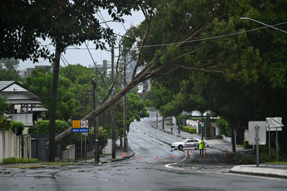
A fallen tree blocked traffic in the Brisbane suburb of Norman Park on Saturday.Credit: Getty Images
“It really has picked up in the last hour or two hours,” the BOM’s senior meteorologist Angus Hines says.
“It’s coming hand-in-hand with a couple of bands of rain and it’s making it feel like conditions have really ramped up after being benign for much of the day.”
Redcliffe, on the city’s northern fringe, has been hit with wind gusts of 96km/h, while in Brisbane and on the Gold Coast they are between 60 and 70km/h.
“And we’re also seeing an extra squeeze in the wind between the ex-tropical cyclone and the high-pressure system below it,” Hines says.
A tropical cyclone is said to “make landfall” when the eye – the centre of the vortex – crosses to the mainland.
Now that Alfred has been downgraded to a tropical low, it technically doesn’t have an eye.
However, senior meteorologist Christie Johnson said that doesn’t matter for identifying landfall because it “does still have a centre of rotation”.
“It doesn’t have an eye in the classic sense that we would expect in a severe tropical cyclone, where there’s an eye wall of a certain cloud structure around it,” Johnson said.
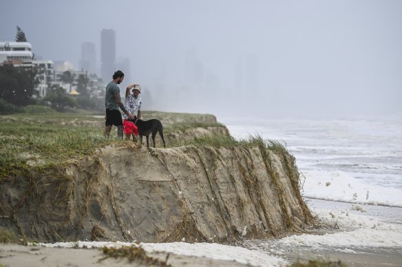
Wild seas and beach erosion on the Gold Coast on Saturday morning.Credit: Dan Peled
“But obviously, as you can see, if you’re looking on the satellite loop or the radar loop, there is a circulation, and there is a centre of that circulation. That is what we’re tracking now when it comes to deciding whether it’s across the coast or not.”
In a strong cyclone, the eye wall is the band of the strongest winds, and then the centre of the eye is calm.
With a weaker cyclone or tropical low, there is no distinct calm in the centre, but the winds are still strongest close to the centre.
People in Brisbane are reporting the winds feel “absolutely nuts” right now and stronger than last night.
Alfred is now a tropical low rather than a cyclone, which reduces wind speeds. However, the vortex is a lot closer to Brisbane than last night.
The Australian Defence Force has released a statement about the crash involving two of its vehicles that has seen up to 36 personnel injured in Northern NSW, some of them seriously.
A Department of Defence spokesperson said the vehicles were providing community support to Lismore following ex-tropical cyclone Alfred.
“A number of ADF personnel have been injured,” they said.
“The welfare of ADF members and their families is a priority and Defence’s focus is on supporting those involved.
“Due to the developing nature of the incident, no further information will be available at this time, however Defence will provide further updates when possible.”
NSW Premier Chris Minns said the ADF personnel had come to the Northern Rivers to keep the community safe.
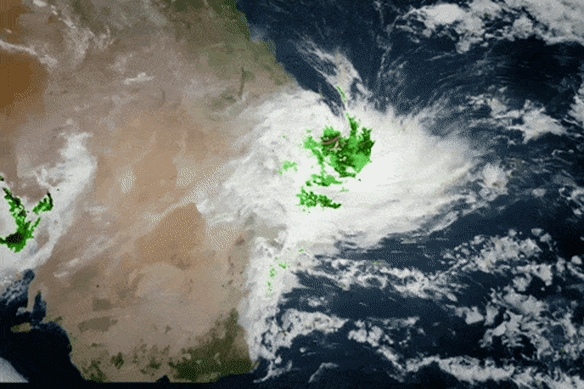
The Bureau of Meteorology is forecasting ex-tropical cyclone Alfred will cross the coast at Bridie Island within the next two hours.
“Ex-tropical cyclone Alfred is slowly approaching the coast at Bribie Island, with a crossing expected in the next hour or two,” the BoM update at 8.45pm said.
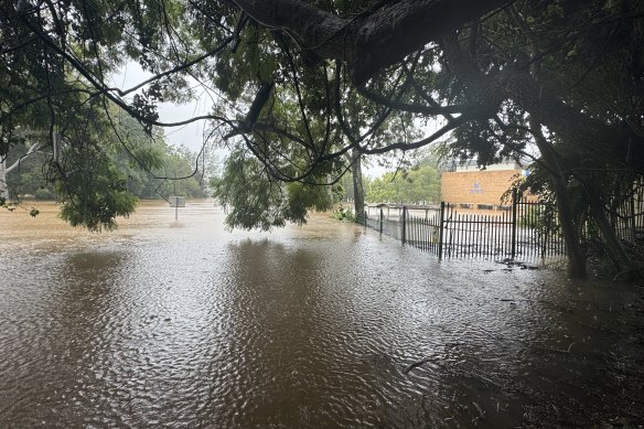
Parts of Lismore were inundated with floodwater on Saturday.Credit: Danielle Smith
While Alfred was downgraded from a category 1 on Saturday morning, the tropical low has brought sustained and intense rainfall as the storm inches closer to the coast.
Residents on both sides of the Queensland-NSW border are confronting property damage, flooding and the loss of power.
We mentioned earlier that the bay islands were protecting Brisbane from the full force of the cyclone.
Alfred approached the coast as a category 2 tropical cyclone, became a category 1 system as it moved over the islands, and then weakened to a tropical low over Moreton Bay.
Senior meteorologist Christie Johnson explained there were “complex interactions” that caused a cyclone or ex-cyclone to weaken when it moved over land.
“One of them is that the system coming over land of any sort, even if it’s just the bay islands, reduces the amount of evaporation and the amount of energy that’s available to the system,” Johnson said.
“Pretty much any tropical cyclone will weaken once it comes over land because it basically loses its connection to its source of energy.”
As reported by this masthead, tropical cyclones require warm sea surface temperatures to form and be sustained.
A marine heatwave around Australia, a recurring feature of global warming, is one of the main reasons Alfred was able to remain a cyclone so far south.
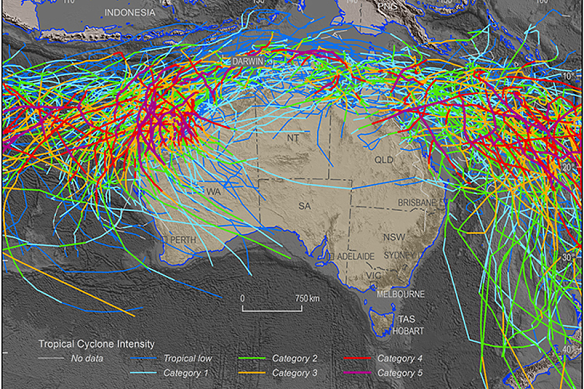
Historical tropical cyclone activity across Australia between 1981 and 2017.Credit: Geoscience Australia
Emergency services are now reporting up to 36 people have been injured in a crash involving Australian Defence Force vehicles near the flood-hit town of Lismore in northern NSW.
Emergency services were called to Tregeagle, nine kilometres south of Lismore, just after 5pm on Saturday after receiving reports two ADF trucks had collided.
Initial reports were that up to 22 personnel had been injured, some seriously, that has now been updated to 36.
A NSW Ambulance spokesman said the emergency response was still under way.
A Brisbane mum has given birth to a premature baby boy in the hours before ex-tropical Cyclone Alfred was scheduled to hit South East Queensland - and he has fittingly been named Alfie.
While seemingly an apt nod to the destructive weather system, his name was picked well before the cyclone began brewing.
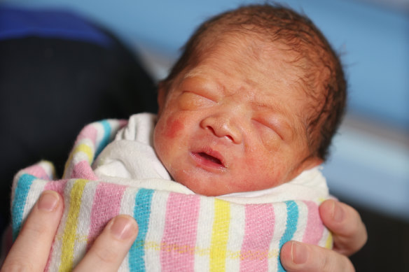
Baby Alfie Zhang.Credit: Annette Dew
Parents Han Zhang and his wife Ning welcomed their son seven weeks early on Wednesday at Mater Mothers’ Hospital. He weighed 1.8 kilograms.
Alfie, who has two older brothers, was born at 33 weeks gestation and is currently still in the neonatal intensive care unit.
“We feel that Alfie is just like a cyclone, when he decided to come out, nothing could stop him,” Zhang said.
“For us it wasn’t quite the calm before the storm, but we are happy he is here now and in safe hands.”
Matthew Collopy from Brisbane Bureau of Meteorology centre appeared alongside Queensland Premier David Crisafulli at a media conference earlier. Here’s an update from Collopy:
Heavy rainfall is expected to continue across south-east Queensland and northern NSW.Credit: The Age
- Wind gusts of up to 95km/h continue on the Gold Coast, severe coastal erosion is still a risk from Cape Morton to Coolangatta.
- Rainfall totals up to 280mm are possible in the 24 hours to 9am. Winds are expected to ease this evening.
Loading