A 3-tonne, $1.5 billion satellite to watch Earth's every move is set to launch this week
In a few days, a new satellite that can detect changes on Earth’s surface down to the centimetre, in almost real time and no matter the time of day or weather conditions, is set to launch from India’s Satish Dhawan Space Centre near Chennai.
Weighing almost 3 tonnes and boasting a 12-metre radar antenna, the US$1.5 billion NISAR satellite will track the ground under our feet and the water that flows over and through it in unprecedented detail, providing valuable information for farmers, climate scientists and natural disaster response teams.
Satellites that image the Earth have been an invaluable scientific tool for decades. They have provided crucial data across many applications, such as weather forecasting and emergency response planning. They have also helped scientists track long-term changes in Earth’s ecosystems and climate.
Many of these Earth observation satellites require reflected sunlight to capture images of Earth’s surface. This means they can only capture images during daytime and when there is no cloud cover.
As a result, these satellites face challenges wherever cloud cover is very common, such as in tropical regions, or when nighttime imagery is required.
The NISAR satellite – a collaboration between the national space agencies of the United States (NASA) and India (ISRO) – overcomes these challenges by using synthetic aperture radar (SAR) technology to take images of the Earth. This technology also gives the satellite its name. NISAR stands for NASA-ISRO SAR.
SAR technology was invented in 1951 for military use. Rather than using reflected sunlight to passively image the Earth’s surface, SAR satellites work by actively beaming a radar signal toward the surface and detecting the reflected signal. Think of this as like using a flash to take a photo in a dark room.
This means SAR satellites can take images of the Earth’s surface both during the day and night.
Since radar signals pass through most cloud and smoke unhindered, SAR satellites can also image the Earth’s surface even when it is covered by clouds, smoke or ash. This is especially valuable during natural disasters such as floods, bushfires or volcanic eruptions.
Radar signals can also penetrate through certain structures such as thick vegetation. They are useful for detecting the presence of water due to the way that water affects reflected radar signals.
The European Space Agency used the vegetation-penetrating properties of SAR signals in its recent Biomass mission. This can image the 3D structure of forests. It can also produce highly accurate measurements of the amount of biomass and carbon stored in Earth’s forests.
Sang-Ho Yun, Director of the Earth Observatory of Singapore’s Remote Sensing Lab, is a key proponent of using SAR for disaster management. Yun has previously used SAR data to map disaster-affected areas across hundreds of natural disasters over the last 15 years, including earthquakes, floods and typhoons.
NISAR, which is due to launch on June 18, will significantly build on this earlier work.

The NISAR satellite has been in development for over a decade and is one of the most expensive Earth-imaging satellites ever built.
Data from the satellite will be supplied freely and openly worldwide. It will provide high-resolution images of almost all land and ice surfaces around the globe twice every 12 days.
This is similar in scope to the European Space Agency’s Sentinel-1 SAR satellites. However, NISAR will be the first SAR satellite to use two complementary radar frequencies rather than one, and will be capable of producing higher resolution imagery compared with the Sentinel-1 satellites. It will also have greater coverage of Antarctica than Sentinel-1 and will use radar frequencies that penetrate further into vegetation.
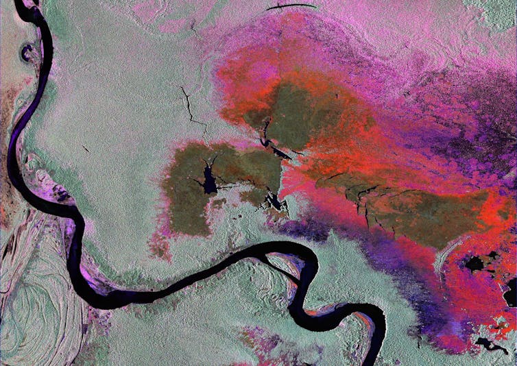
The NISAR satellite will be used to monitor forest biomass. Its ability to simultaneously penetrate vegetation and detect water will also allow it to accurately map flooded vegetation.
This is important for gaining a deeper understanding of Earth’s wetlands, which are important ecosystems with high levels of biodiversity and massive carbon storage capacity.
The satellite will also be able to detect changes in the height of Earth’s surface of a few centimetres or even millimetres, because changes in height create tiny shifts in the reflected radar signal.
The NISAR satellite will use this technique to track subsidence of dams and map groundwater levels (since subsurface water affects the height of the Earth’s surface). It will also use the same technique to map land movement and damage from earthquakes, landslides and volcanic activity.
Such maps can help disaster response teams to better understand the damage that has occurred in disaster areas and to plan their response.
The NISAR satellite will also be useful for agricultural applications, with a unique capability to estimate moisture levels in soil with high resolution in all weather conditions.
This is valuable for agricultural applications because such data can be used to determine when to irrigate to ensure healthy vegetation, and to potentially improve water use efficiency and crop yields.
Further key applications of the NISAR mission will include tracking the flow of Earth’s ice sheets and glaciers, monitoring coastal erosion and tracking oil spills.
We can expect to see many benefits for science and society to come from this highly ambitious satellite mission.


