Sydney weather LIVE: Sever weather warning in Sydney, NSW triggered by 'Bombogenesis' as rain sets in
Good morning and welcome to The Sydney Morning Herald’s live coverage of today’s weather, as a rapidly intensifying low-pressure system off the east coast brings heavy rain and wild winds to Sydney and around the state.
Here’s what we know so far.
- The rapid intensification of the low into a fierce weather system, dubbed “bombogenesis” by meteorologists, is a rare event most often seen during winter. You can read more about the science of the phenomenon here.
- The forecast movement of the coastal low would cause damaging winds and heavy rain to persist into tomorrow.
It was only just over a month ago that the Mid North Coast experienced its worst flood disaster in living memory. Five people died and hundreds of homes were destroyed.
Now locals are bracing for yet more wild weather, with strong winds and flash flooding expected to lash the coast.
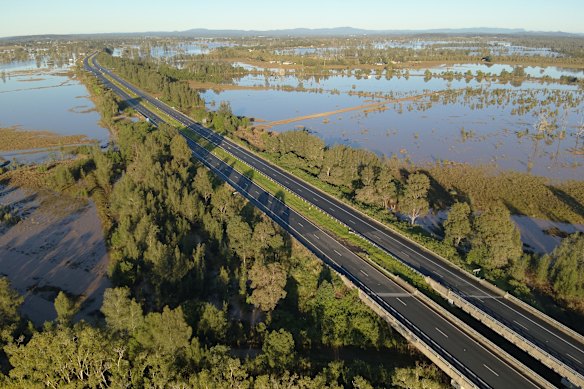
Days of intense rain caused widespread flooding throughout the NSW Mid North Coast in May.Credit: PR IMAGE
Damaging south to southwesterly winds will average 60 to 70 km/h while gusts could reach up to 110km/h, with the risk of isolated 125km/h gusts intensifying into the afternoon, and threatening to bring down trees and damage property.
The Bureau of Meteorology says the heavy rainfall forecast could bring the possibility of flash flooding, with sic-hour rainfall totals likely to reach between 70 and 90 mm or up to 120mm in isolated falls.
Commuters across the Spit Bridge this morning are being significantly slowed down by a lane closure caused by water on the road.
City-bound workers leaving the Northern Beaches will have to contend with the three lanes narrowing to two just north of the bridge, where water is all over the roadway and the left lane is shut.
Workers on the scene at about 8.15am were attempting to deal with what appeared to be an overflowing water main.
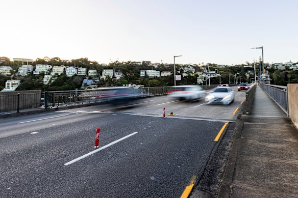
Spit Bridge in Mosman in 2024.Credit: Ben Symons
You might have seen the term “bomb cyclone” used to describe this weather event, so what does it actually mean, and why won’t you see the Bureau of Meteorology call it that?
The latest severe weather warning issued by the bureau describes a “rapidly deepening complex low-pressure system” that is “forecast to develop a vigorous coastal low offshore”.
Some media are calling this phenomenon a “bomb cyclone”.
Loading
Asked about the term on Nine’s Today, BoM meteorologist Jonathan How explained that “bomb cyclone” is an official meteorological term that describes how quickly this low-pressure system is deepening.
But that doesn’t mean BoM likes to use it.
“We don’t really use that term very much. We just talk about a low-pressure system deepening very quickly because ‘bomb’ can sort of create a little bit more panic and [is] a little bit more scary than what it actually is,” he said.
So with the coastal low deepening, we can call the phenomenon a “bomb cyclone”, but keep in mind it’s not officially a cyclone, and there’s no bomb.
It’s more used to conjure the imagery of a sudden and significant drop in atmospheric pressure, like a bomb going off, that turns into a powerful and rapidly intensifying storm.
You can read more about the system and the rapid intensification or “bombogenesis” taking place, here.
Boaters have been told to stay ashore, as NSW Maritime issues official advice to avoid non-essential boating activity over the coming days.
A coastal hazard warning is in place, with the east coast low set to bring damaging surf and wind to NSW, with the worst to set in from this evening, and possibly continue through to Thursday morning.
“We are advising everyone to stay off the water over the next couple of days, and boaters should check moorings and secure any items on board,” NSW Maritime Executive Director Mark Hutchings said.
“The storms forecast for parts of the NSW coast bring with them the risk of waterspouts, which can be incredibly dangerous for boaters.”
Hutchings said he didn’t want to see anyone take “unnecessary risks”.
“Please stay informed, and don’t go out on the water unless you absolutely have to.”
We’ve had plenty of time to prepare for this weather event, and that means SES personnel have been deployed around the state and are ready for whatever comes next.
SES crews have already responded to 600 incidents in the last 24 hours, with more than 1000 volunteers activated to help out in their local communities.
“We are really concerned about flash flooding, particularly around the commute home for people this afternoon, as we see those rainfall figures escalate throughout the day,” NSW SES Chief Superintendent Dallas Burnes told Nine’s Today.
Aside from the risk of flash flooding, Burnes said the state needs to be prepared for the winds.
“If they get those gusts up to 125km/h, we are going to see trees come down. People need to be aware of where they are, where they’re parking, what is a possible danger to them. And if they can avoid travel, do so,” he said.
“And of course, if the roadway is flooded, please do not go through those roads. Find an alternate route.”
The latest outlook from the Bureau of Meteorology suggests there could be as much as 200mm of rain in parts of the state as NSW battens down the hatches.
“We’re already seeing that rainfall building across Newcastle, Sydney and down towards Wollongong. We’ll see that rain continuing through the day today, easing in Sydney later this afternoon and into the evening,” Bureau of Meteorology meteorologist Jonathan How told Nine’s Today.
“The heaviest of the rain will be from Wollongong southwards all the way [to] Merimbula. We could see upwards of 100, even 200mm of rainfall along that South Coast over the next couple of days, and we could see that flooding.”
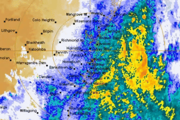
A Bureau of Meteorology radar shows the rain sweeping across the coastline.Credit: BOM
How said the biggest risk for Sydney and Newcastle would likely be the winds, which will pick up in the afternoon.
“They could cause some trees to come down with debris to sort of be tossed around,” he said.
From Wednesday, the surf conditions will worsen, and risk of coastal erosion will intensify.
“We are reminding everyone across eastern NSW and south-east Queensland to keep an eye on the warnings,” How concluded.
Sydneysiders who decide to brave the office today should find their morning commute largely unaffected, if a little wet.
It’s the evening commute that’s likely to experience major issues, as the wet weather is expected to peak in the afternoon right around the time office workers will be making their way home.
Transport for NSW has issued a plea for motorists and public transport users to prepare, and allow additional travel time in case of delays or sudden road closures.
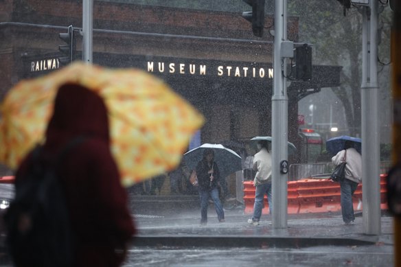
A picture from May shows a rainy day outside Museum Station in Sydney’s CBD.Credit: Sam Mooy
“Don’t drive, walk or cycle through flood waters, watch out for storm debris on the road, and if weather conditions become too severe, find a safe place to stop and wait until it passes,” Transport for NSW Coordinator-General Howard Collins said.
Collins said the department is working with other agencies to ensure the public transport network is prepared for the impacts of the weather system.
“Passengers on public transport should take the time to hop online and check
timetables before they set off and stay across any updates during their trip,” he said.
We’re starting to see the first impacts on flights around the state, with the major airlines preparing for cancellations to mount as the weather worsens.
Virgin is advising guests travelling in and out of Sydney and Newcastle that their flights may be impacted by the wild weather, while a Qantas spokesperson says it anticipates more cancellations in and out of Sydney later today.
Twelve Virgin and seven Qantas flights have been cancelled so far today.
“We encourage guests travelling today and tomorrow to keep an eye on the status of their flight via our website or app,” a Virgin spokesperson said in a statement.
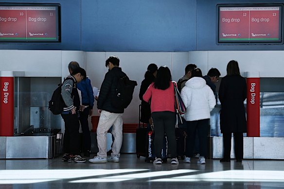
Passengers at Sydney airport last year.Credit: Kate Geraghty
Conditions are expected to intensify throughout the day, but for now, it’s already pretty rainy out there.
The Herald’s chief photographer Nick Moir braved the rain this morning to capture Manly locals on the move in the wet weather.
It’ll be a rainy commute to work, but so far, public transport is running as scheduled.
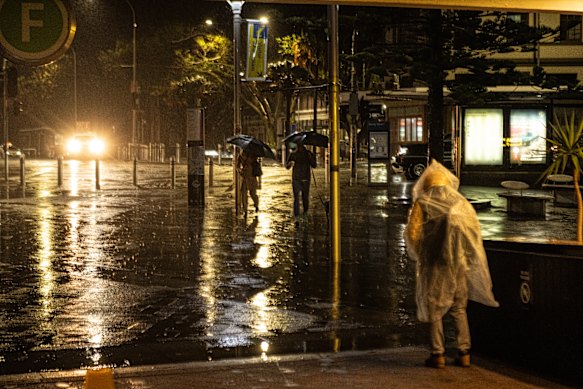
Pedestrians brave the rain in Manly. Credit: Nick Moir
The SES has deployed 395 volunteers across the coast and positioned high-clearance vehicles to Kiama, Albury, Hawkesbury, Maitland and Dungog, as NSW braces for the latest wild weather event.
Emergency vehicles and helicopters were also deployed to Taree, which is still reeling from May’s flood disaster.
“This is a time for our communities across NSW to be very vigilant and very prepared. We’re looking at thunderstorms, rain, strong winds, coastal erosion and damaging surf,” SES deputy commissioner Debbie Platz said.
Platz urged people to download the Hazards Near Me app, secure outdoor furniture and trampolines, clear gutters and move vehicles away from large trees.
Loading