Strong storms followed by dangerous summer heat coming to Maryland - CBS Baltimore
/ CBS Baltimore
Stormy weather will impact Maryland through Thursday
A stretch of unsettled and increasingly hot weather is setting up for Maryland, with severe storms possible midweek and the hottest temperatures of the year likely arriving by early next week.
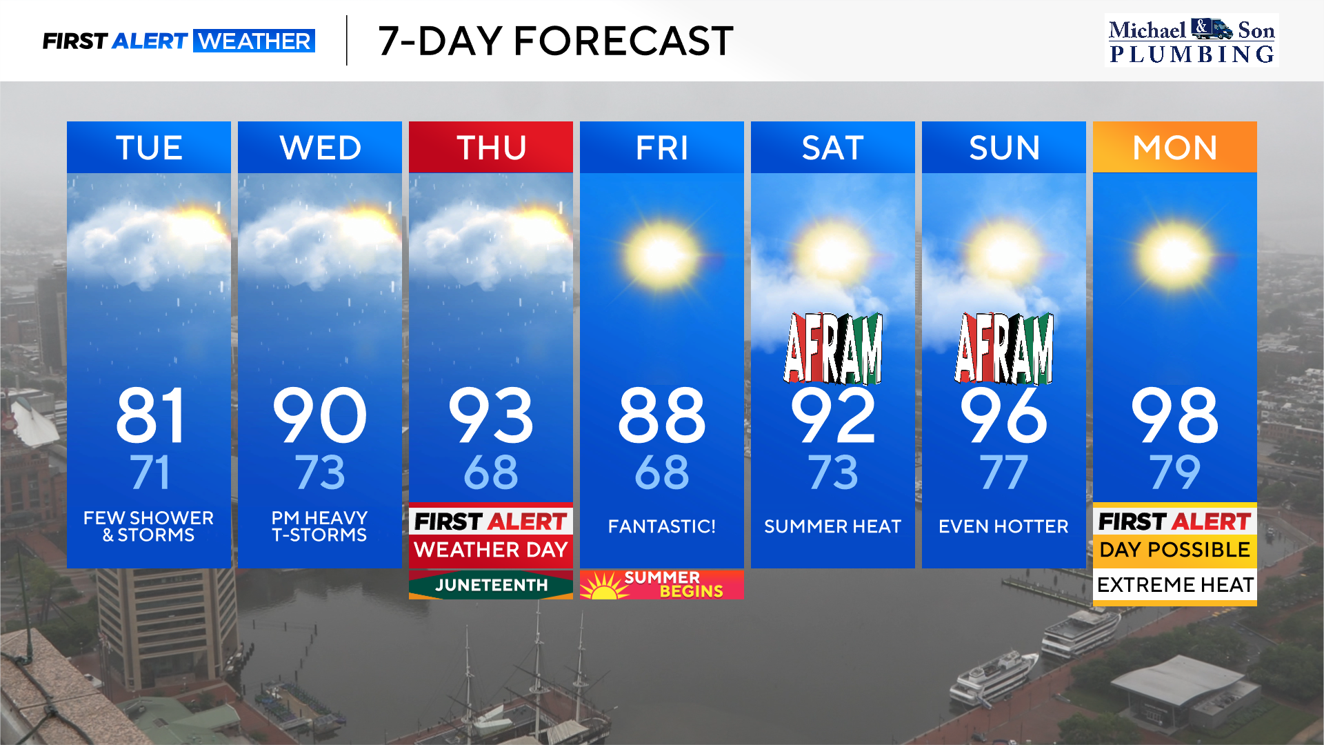
A few strong storms may develop this evening, mainly across areas west and south of Baltimore. The rest of the night will be partly cloudy and warmer, with overnight lows near 70 degrees.
Heat and humidity will build quickly Wednesday afternoon. Temperatures will reach near 90 degrees, and the heat index could climb into the mid to upper 90s. Scattered afternoon storms are expected, with the potential for a few strong to severe cells. Gusty winds are the most likely severe weather threat. The Storm Prediction Center (SPC) has placed most of Maryland under a Level 1 Marginal Risk for severe weather. Storm chances will diminish Wednesday night, with overnight lows in the low 70s.
Another round of stronger storms is expected Thursday afternoon and evening as a cold front moves through. The SPC has upgraded the severe weather threat to a Level 2 Slight Risk across most of the state. Storms that develop after 3 p.m. could produce damaging wind gusts, hail, torrential downpours, and frequent lightning. Storms will end before midnight. Highs ahead of the front will soar into the low to mid-90s, and the heat index may reach 100°.
Slightly cooler and less humid air will follow the front on Friday, but temperatures will still climb into the mid to upper 80s under mostly sunny skies. However, a strong upper-level ridge will begin building over the region this weekend, leading to an extended stretch of intense heat.
High temperatures on Saturday will reach the low 90s, with heat index values in the mid-90s. If you're heading to AFRAM this weekend, be sure to take precautions: hydrate frequently, wear light-colored, breathable clothing, and limit prolonged outdoor exposure.
By Sunday, the heat intensifies further. Highs in the mid-90s will be accompanied by heat index values near 100 degrees.
The hottest weather of the year is expected Monday through Wednesday. Highs Monday will reach the upper 90s with heat index values approaching 105°. Tuesday could see actual air temperatures near 100°, with feels-like values even higher. Heat advisories or Excessive Heat Warnings will likely be issued. Wednesday looks equally oppressive, with upper 90s and heat indices again in the 100–105° range.
The high-pressure system responsible for the heat will begin to weaken by late next week. Thursday's highs will remain in the mid-90s, and forecast models diverge slightly on whether storm chances will return that afternoon. The American GFS model suggests a quicker breakdown of the ridge and a return to scattered storms, while the European model holds off a bit longer.
Highs Friday will again reach the low 90s with heat index values in the upper 90s. Forecasters are keeping a close eye on the potential return of scattered storms by next weekend, but confidence remains low for now.
Marylanders should prepare for a prolonged stretch of hot and humid weather beginning this weekend and continuing through much of next week. Stay cool, stay hydrated, and monitor for any heat-related alerts by staying with WJZ's First Alert Weather Team.
Derek Beasley joined the WJZ First Alert Weather Team in March 2022. He was promoted in March 2023 to become WJZ's first-ever Chief Meteorologist.