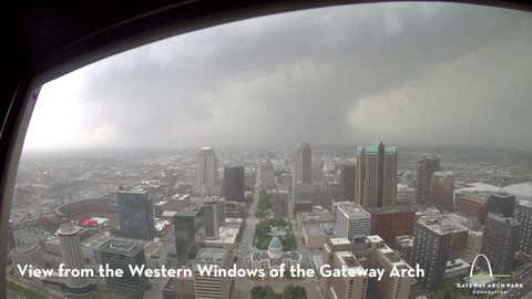
A damaging tornado struck the St. Louis metro area, captured by a camera providing a live feed atop The Gateway Arch.
(National Park Service)
A tornado tore through the St. Louis metro area Friday afternoon, bringing significant damage, large hail, and destructive winds up to 60 mph. The storm, which had already produced confirmed 2.5-inch hail, left a trail of destruction as it moved rapidly through the city.
The National Weather Service confirmed that a tornado touched down in the suburb of Clayton, Missouri, and moved toward the north side of downtown St. Louis. Radar detected tornado debris lofted up high enough to indicate that the tornado may have been EF2 to EF3 strength damage. A tornado survey will be required to learn its exact strength.
As the tornado crossed the Mississippi River just north of downtown, damage reports began pouring in. Bystanders captured video of the aftermath, including a downtown building with its roof ripped off.
Emergency officials reported at least one building struck by debris, shattered windows, and numerous injuries, while videos posted to social media showed trees littering the streets and vehicles covered by fallen branches.
City workers reportedly took shelter in the basement of City Hall as the tornado approached, according to local media.
Among areas that may have been impacted, based on radar and traffic disruptions, were parts of the Washington University campus, the St. Louis Zoo grounds, and a section of the MetroLink light rail line north of the zoo.
In Clayton, a massive tree was uprooted at Concordia Seminary, with its trunk moved several feet by the storm’s force.
Residents are urged to remain sheltered and avoid affected areas as the full extent of the damage and injuries was still being assessed. Tornado and severe thunderstorm warnings are in place for several surrounding counties.
The threat for other parts of the Midwest continues as well.
From senior meteorologist Jonathan Erdman:
"Today's storms in the mid-Mississippi Valley and Ohio Valley make up just one chapter of a dangerous multi-day severe weather saga that will begin to shift its emphasis to the Central and Southern Plains this weekend and last at least through Tuesday."
For more on that forecast, click here.
Weather.com lead editor Jenn Jordan explores how weather and climate weave through our daily lives, shape our routines and leave lasting impacts on our communities.