Reuters
Erick intensified rapidly in less than 24 hours, morphing from a moderate hurricane into what experts called an “extremely dangerous” system. This rapid strengthening, driven by warm ocean waters and favorable atmospheric conditions, turned Erick into —and the earliest "E" storm on record.
The storm made landfall near , packing sustained winds around after briefly reaching overnight. Hurricane Erick came ashore around 6 a.m. local time near Punta Maldonado in western Oaxaca, moving northwest through the region. At the time of landfall, Erick had maximum sustained winds of 125 mph, making it a Category 3 hurricane on the Saffir-Simpson scale. Earlier on Wednesday night, it had intensified rapidly from a tropical storm to a Category 4 hurricane, with its wind speeds doubling in just hours.

According to the U.S. National Hurricane Center, the storm was expected to produce 8 to 12 inches of rain across most areas it passed, with some locations possibly receiving up to 16 inches, especially in high-risk regions of Oaxaca and Guerrero. Authorities in declared a , Mexico’s highest warning level, urging residents to take shelter immediately. The storm’s path stretched from , prompting widespread evacuations, school closures, and a halt to non-essential activities. More than were opened, and over were deployed across the affected states. Hurricane Erick made a destructive landfall along Mexico’s southern Pacific coast, bringing devastating winds, flash floods, and dangerous surf. Here's a breakdown of the most affected locations:
Direct hit and landfall area:
Severely impacted coastal cities:
Broader danger zone:
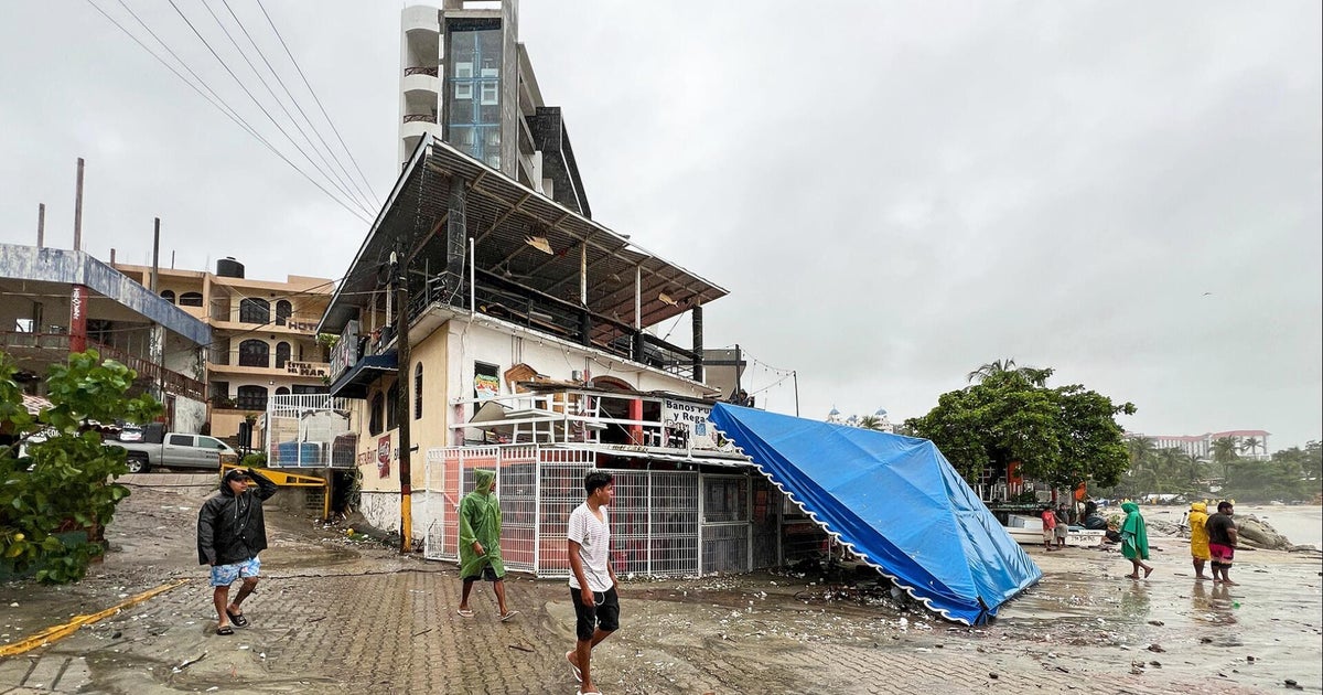
These regions are dealing with up to , severe flash flood risk, and potential mudslides in mountainous zones. The biggest threats aren’t just from wind—though gusts toppled trees and damaged homes—but from relentless rainfall. Meteorologists are warning of up to 16 inches (40 cm) of rain in some areas, raising fears of life-threatening flash floods and mudslides, especially in mountainous terrain. Coastal regions are also bracing for storm surge and waves up to 33 feet (10 meters). In preparation for the storm, Mexican authorities responded swiftly. Over 2,000 temporary shelters were established in Guerrero, Oaxaca, and Chiapas. A hurricane warning was issued for a 300-mile stretch of coastline from Puerto Ángel to Acapulco. President Claudia Sheinbaum urged residents living in low-lying areas, near rivers or waterways, to evacuate to these shelters and avoid venturing out.“If you are in low-lying areas, near rivers, near waterways, it is best for you to go to shelters... Anyone who has a boat should not go out,” Sheinbaum emphasized during a Wednesday morning news conference.
The storm caused widespread disruption even before landfall. In Lagunas de Chacahua, over 100 residents — many of them fishermen and tourism workers — took refuge in schools. In Salina Cruz, a vital seaport in Oaxaca, streets were flooded, and cars were left stranded. Local police worked through the day clearing rocks, debris, and fallen branches from blocked roads.Residents and business owners in Puerto Escondido boarded up windows in anticipation, and tourists were advised to remain indoors. In affected areas of Oaxaca, schools were closed for the second day in a row, according to Emilio Montero Pérez, the state’s education chief.
Yes, according to the National Hurricane Center, the greatest threats are heavy rainfall, flash floods, and dangerous mudslides. The forecast of up to 16 inches of rain in some locations raises the alarm, particularly for mountainous terrain where saturated soil can trigger deadly landslides.Authorities are closely watching dams and rivers to prevent overflow. Coastal areas are also experiencing large waves and strong swells, increasing the risk of storm surge and flooding along beaches and river mouths.
Hurricane Erick’s rapid intensification has drawn comparisons to Hurricane Otis, which struck Mexico’s Pacific coast in 2023 as a Category 5 hurricane, killing over 50 people and devastating the city of Acapulco. Otis’s damage included sunken yachts, flattened homes, and destroyed hotels.While Erick made landfall with less intensity than Otis, its fast development and projected rainfall totals are serious enough that authorities are urging residents not to underestimate the threat. As the fifth named storm of the 2025 Pacific hurricane season, Erick highlights ongoing concerns about stronger and faster-developing tropical systems.
Authorities are urging everyone in the danger zones to:- , as rough surf and deadly rip currents are expected to persist even after the storm weakens.
As Hurricane Erick continues inland, its winds are expected to die down, but the danger from flooding, mudslides, and rough seas remains very real. Residents across Oaxaca and Guerrero are being urged to stay sheltered, avoid travel, and follow updates from Civil Protection and the National Hurricane Center. With heavy rain forecast through Friday, the focus now shifts to managing post-landfall conditions and ensuring safety in affected communities.
Hurricane Erick made landfall near Punta Maldonado, in Oaxaca.
Q2: How strong was Hurricane Erick when it hit Mexico?
Hurricane Erick hit as a Category 3 storm with winds around 125 mph.
Read More News on
(Catch all the US News, UK News, Canada News, International Breaking News Events, and Latest News Updates on The Economic Times.)
Download The Economic Times News App to get Daily International News Updates.