From Orbit to Outlook: How LEO Satellites Enhance Weather Forecasting | NESDIS
Low Earth orbit (LEO) satellite data is a cornerstone of modern weather forecasting at NOAA’s National Weather Service (NWS), supporting the Weather Prediction Center (WPC) and Ocean Prediction Center (OPC) in their mission to protect lives, property and the economy. Operational forecasters benefit from the detailed atmospheric, oceanic and terrestrial data provided by LEO satellites, including NOAA’s Joint Polar Satellite System (JPSS) missions, which orbit pole to pole every 101 minutes. By integrating LEO observations into their workflow, NWS meteorologists achieve improved long-term and near-term forecast accuracy, helping communities better prepare for severe weather.
Satellite liaisons, such as Christopher L. Smith from the Cooperative Institute for Satellite Earth System Studies (CISESS), play a critical role in ensuring NWS forecasters at the WPC and OPC effectively use LEO satellite data. Acting as a bridge between researchers and operational meteorologists, Smith introduces new satellite products to forecasters and gathers feedback to refine these tools. This routine collaboration ensures that satellite data products are both practical and impactful, ultimately leading to more informed and timely public advisories.
One powerful example of an operational LEO satellite data product at the WPC and OPC is the Advected Layer Precipitable Water (ALPW) product, developed by the Cooperative Institute for Research in the Atmosphere (CIRA). ALPW offers detailed, multi-layered views of atmospheric moisture, helping forecasters more accurately identify and monitor atmospheric rivers and assess flooding risks. Additionally, the WPC is currently evaluating experimental products, such as CIRA’s Layered Water Vapor Transport and Percentile Rankings of ALPW, which indicate anomalies in ALPW values based on a 10-year climatology. These tools have the potential to further enhance forecast accuracy and timeliness.
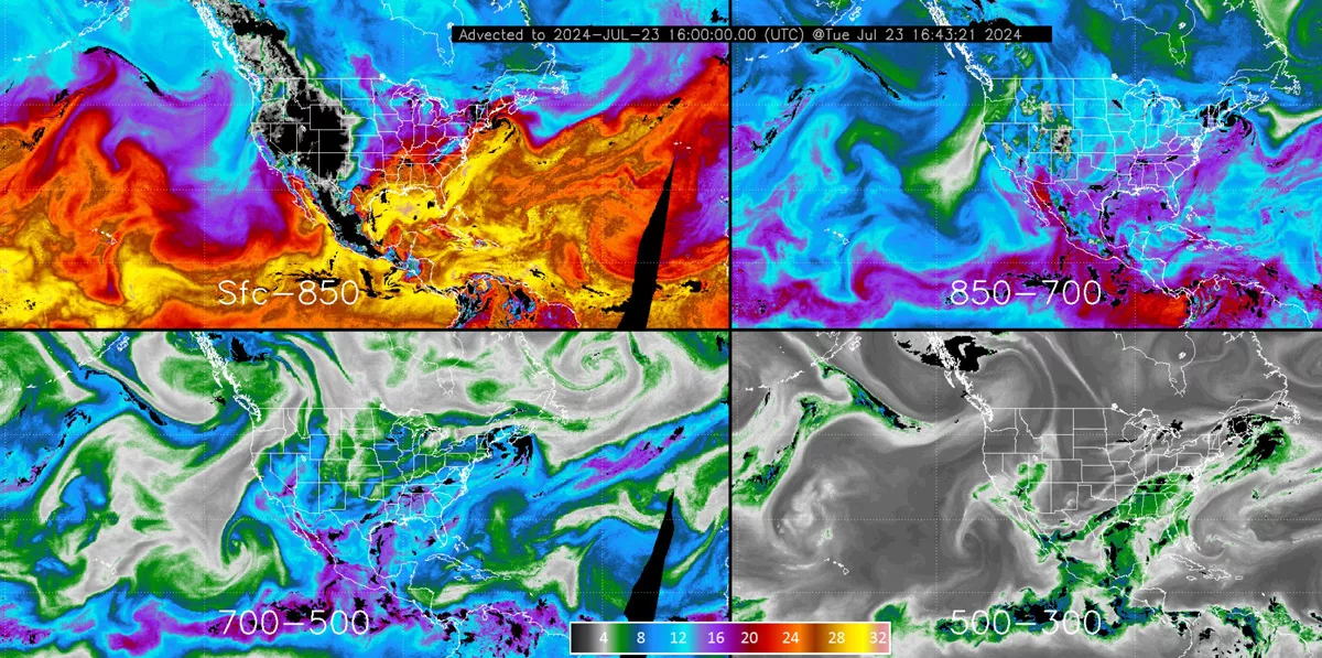
The CIRA Advected Layered Precipitable Water (ALPW) product, derived from Microwave Integrated Retrieval System (MiRS) retrievals of moisture and temperature from seven polar-orbiting satellites, shows atmospheric water vapor across four atmospheric layers (surface–850 millibars (mb), 850–700 mb, 700–500 mb, 500–300 mb). This hourly loop from July 23, 2024, (16:43 UTC) highlights higher moisture levels (red, orange, yellow), useful for assessing atmospheric river depth. Approximate altitudes: 850 mb (~1457 m), 700 mb (~3011 m), 500 mb (~5572 m), 300 mb (~9160 m). Source: CIRA.
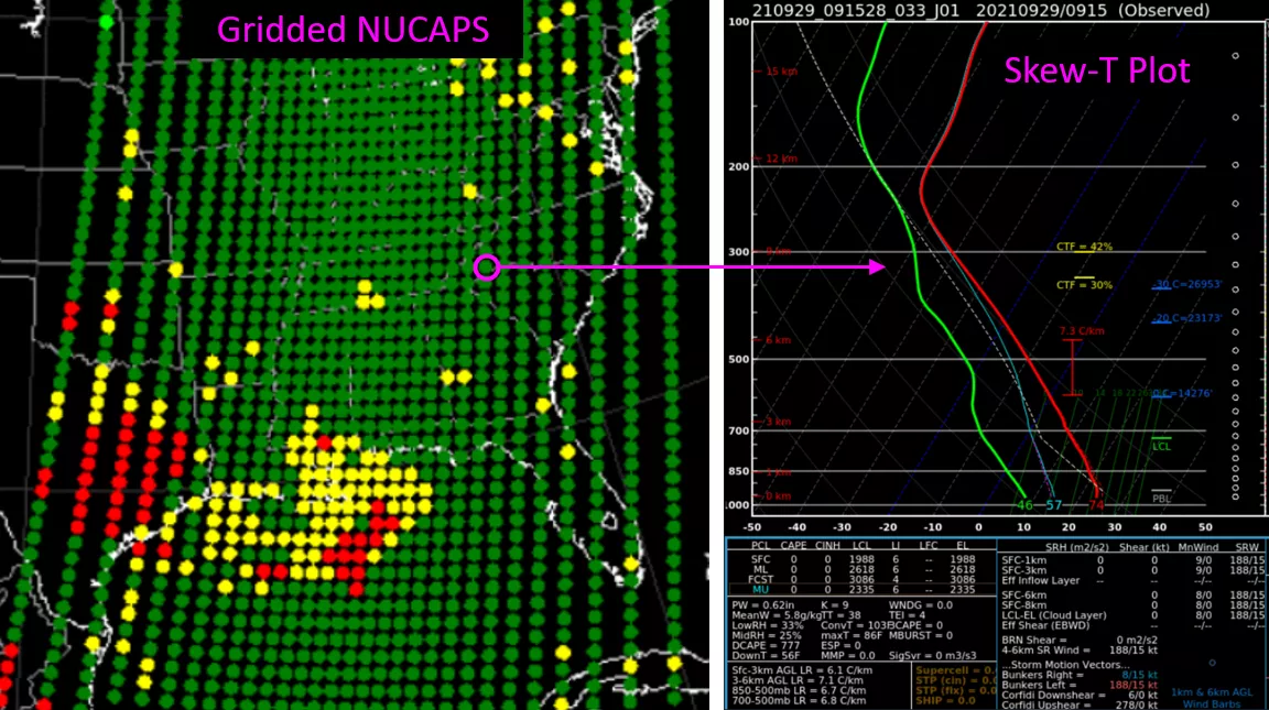
The Gridded NUCAPS product (left) provides horizontal and cross-sectional views of temperature, moisture, and other thermodynamic variables that forecasters use to assess atmospheric conditions at different atmospheric pressure levels. Each dot represents a satellite retrieval, with green indicating successful retrievals that combine measurements from infrared and microwave sounders. For each dot, a “Skew-T” plot is produced (top right) that describes the conditions in the atmospheric column at that location. From these values, atmospheric stability parameters are derived (bottom right).
Meteorologists also utilize the versatile JPSS Visible Infrared Imaging Radiometer Suite (VIIRS) for a wide range of applications, including detecting nighttime fog, tracking blowing snow during winter storms, monitoring wildfires, identifying burn scars linked to flash flood risks and more. Its high-resolution imagery captures subtle meteorological details during both day and night, helping meteorologists produce accurate daily and long-term forecasts while also providing emergency managers critical information to effectively respond to disasters and safeguard lives and property.
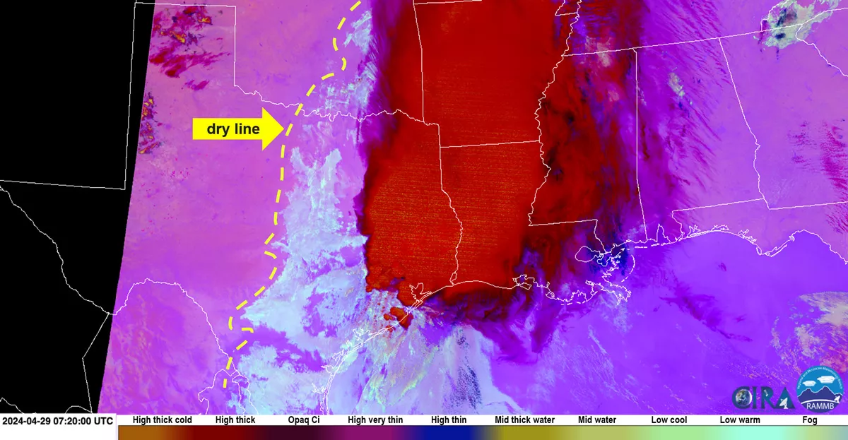
The VIIRS Nighttime Microphysics RGB for the Gulf States on April 29, 2024 (07:20 UTC) shows details of fog (aqua shading) east of the dry line (source: CIRA). The product helps WPC and OPC forecasters detect fog and moisture boundaries, which often signal weather fronts.
LEO observations have transformed weather forecasting at NWS, significantly improving forecasts at the WPC and OPC. Operational forecasters now have greater accuracy in predicting severe weather, tropical cyclones, winter storms, flooding, wildfires and other hazards, enabling communities to better prepare for emergencies and mitigate risks to lives and infrastructure. As forecasting challenges become increasingly complex, the expanding suite of LEO satellite products will ensure the NWS and the nation remain ready and resilient. For more on how these and other LEO satellite data products support operational forecasting, explore the article LEO Data Products in Action at NWS Weather and Ocean Prediction Centers in the 2024 LEO Science Digest.