Extreme Heat Warning goes into effect today, lasts through Wednesday - CBS Pittsburgh
/ CBS Pittsburgh
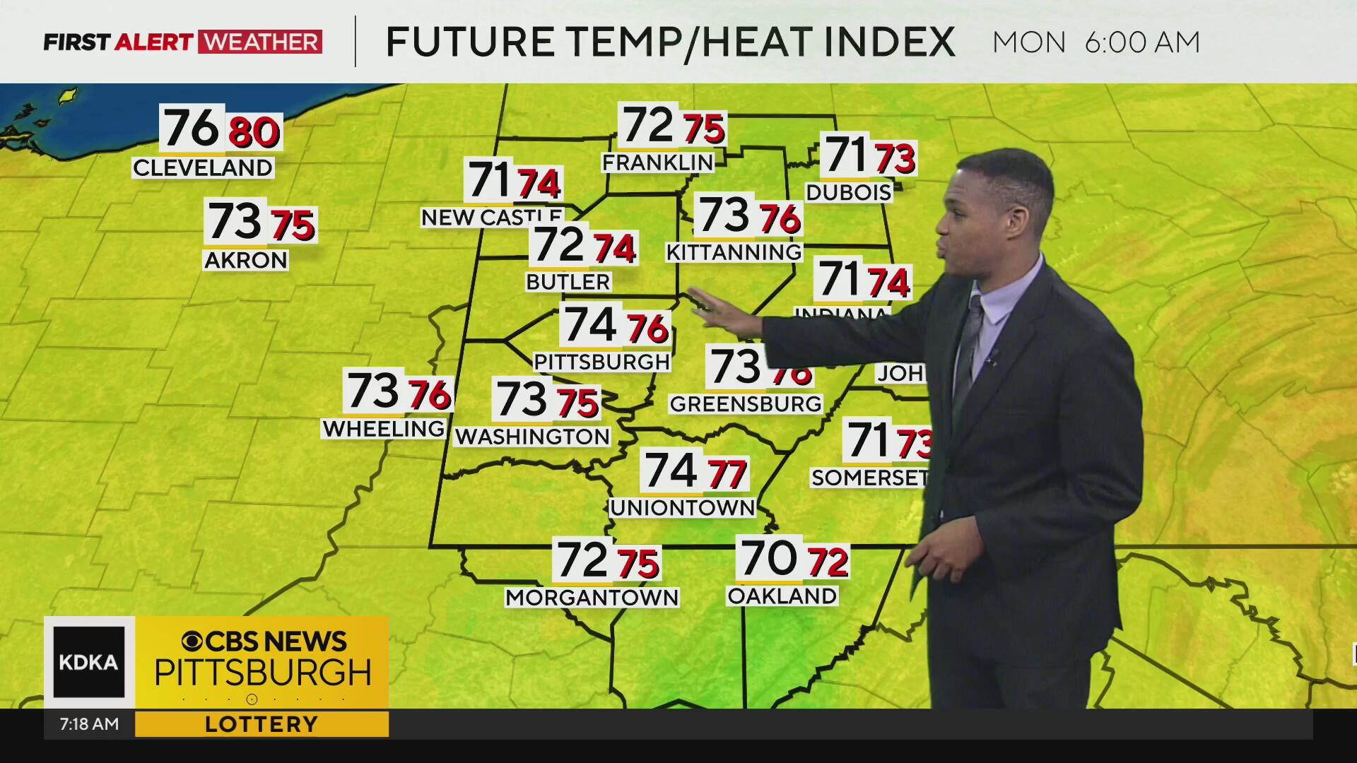
KDKA-TV Morning Forecast (6/22)
Our first bout of excessive heat of the summer builds in today as a strong ridge of high pressure aloft in the atmosphere, aka "heat dome," shifts from the Central US to the Eastern US.
Current Conditions | School Closings & Delays | Submit Your Weather Photos
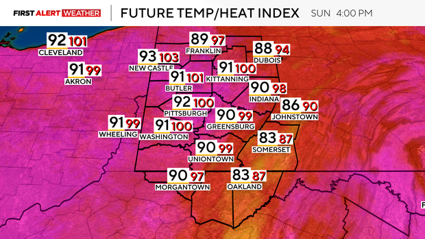
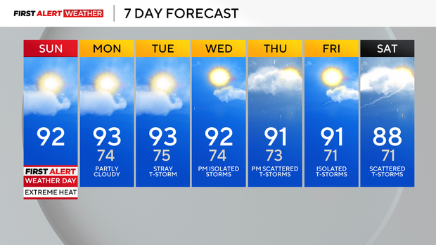
Not only will a hot airmass shift toward our area, but dew points are expected to climb as well into the low to mid 70s. Sunday will feature our first 90-degree day of the year, with plenty of opportunities into the upcoming week as well.
Most models agree that the core of the heat dome will peak in intensity and park directly over the Ohio Valley and Mid-Atlantic states Monday and Tuesday. The saving grace for the Pittsburgh metro and a majority of our region is that our soils are very moist, and the evaporation of this moisture should keep afternoon air temperatures in check, mostly reaching the low to mid-90s.
Despite this, it will be VERY humid, and this will lead to heat indices between 100-105F today through Wednesday during the afternoon.
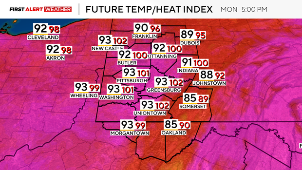
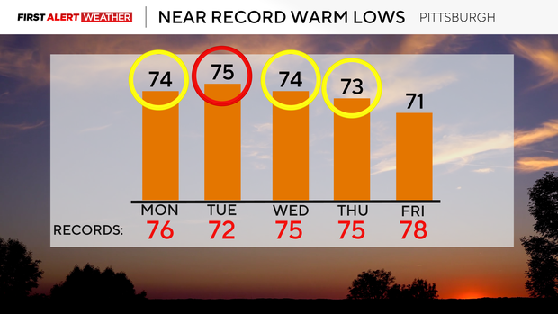
Concerning high temperature records, the days Pittsburgh will be closest to record highs will be Monday (95F set in 1894) and Tuesday (96F set in 1882). DuBois, Pa., and Morgantown, West Virginia, which are other sites in our coverage area that keep long-term climate records, may also break record highs from Monday to Wednesday.
While we may stay just shy of record highs, record warm low temperatures are very likely to be met in Pittsburgh, along with Morgantown and DuBois. Air temperatures will struggle to drop below 70°F at night, which makes this heat very dangerous for those who don't have air conditioning.
Extreme heat is the leading killer of all weather-related hazards, so individuals should take precautions in this upcoming stretch.
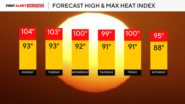
As far as rain chances go for this week, we may see a stray shower or storm pop up in the heat of the day on Tuesday, mainly due to how hot temperatures will be near the ground, accompanied by much moisture. Slightly better chances of showers and storms look plausible on Wednesday and Thursday as the core of the heat ridge breaks down and a weak front moves into the area.
This front does not look as potent as in earlier model runs, so it is possible the stretch of 90-degree weather may continue all the way through the end of the week.
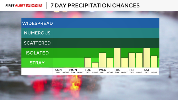
A second and stronger cold front may bring a better chance of rain and storms by Saturday into the following Sunday. Any thunderstorms that form, especially during the heat of the day, may carry a localized damaging wind threat.
Stay up to date with the KDKA Mobile App – which you can download here!


:max_bytes(150000):strip_icc():focal(745x295:747x297)/Tom-Caltabiano-Ray-Romano-Paley-Museum-2025-062025-ff702561385040dc8d228448d87dd329.jpg)


