Weather alert days for severe storms across Maryland Wednesday & Thursday - CBS Baltimore
/ CBS Baltimore
Severe storms expected across Maryland Wednesday & Thursday
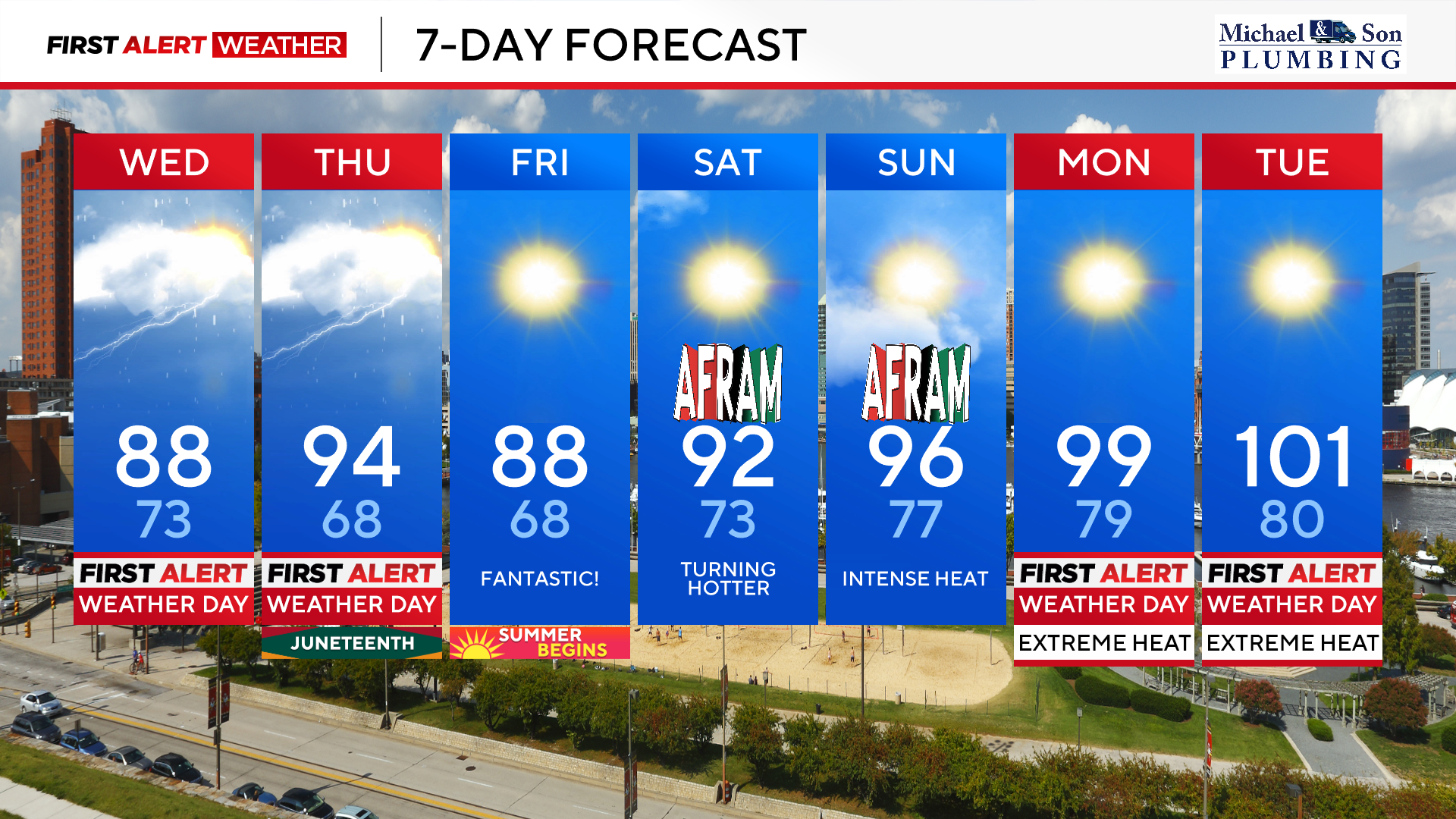
After powerful overnight storms impacted Maryland overnight, more strong to severe thunderstorms are possible this afternoon and evening along with Thursday afternoon and evening.
The WJZ First Alert Weather Team has issued First Alert Weather Days Wednesday and Thursday for the potential for severe storms and heavy rainfall. The best chance for these nasty storms both days will be between 2 pm and 8 pm. Damaging winds, torrential downpours, and intense lightning are possible with any storms. Please stay weather aware and have the CBS News App downloaded to your phone so you can receive any severe weather watches and warnings issued.
In addition to damaging winds, which may snap tree limbs, knock down trees, and cause power outages, especially on Thursday, there is the potential of localized flash flooding in spots. This will be especially true in areas that received heavy storms overnight. Any additional 1 to locally 3 inches of rain are possible with storms.
We'll see two rounds of heat and humidity over the next seven days. The first round of heat and humidity will be felt today and Thursday.
Today's high temperatures will reach the upper 80s to near 90°. Factor in the high humidity and heat index values will reach between 95° and 100° today and heat index values may reach the lower 100s by Thursday afternoon.
Friday will see a break for the tough heat and humidity with highs in the upper 80s and a noticeable drop in the mugginess. This will be the best weather day over the next seven days.
Heat will return over the weekend with typical Maryland summertime temperatures on Saturday with highs in the lower 90s. Humidity on Saturday will be tolerable, but it's still a day you'll want to stay hydrated and take breaks from the heat.
Even hotter weather builds into the area Sunday with highs in the middle 90s and humidity values on the rise. This means the heat index values will top out around 100°.
If you're headed to AFRAM this weekend the weather will be dry, but hot! Please take all of the heat precautions including staying hydrated, wearing sun protection along with light weight and light colored clothing.
The beaches this weekend will have perfect weather with a daily sea breeze keeping high temperatures in the lower 80s with plenty of sunshine. It's a perfect weekend to head down to the Atlantic beaches in Delaware and Maryland.
An extended stretch of dangerous heat and humidity will begin Monday. A large area of high pressure will serve as a heat dome across our area. This means we'll see temperatures climbing into the upper 90s to lower 100s. In addition to the oppressive heat, humidity levels will be running high as well. This means heat index values of 100° to 110° will be possible.
The worst stretch of heat looks to last Monday through Thursday. It's very important that you prepare you, your family, friends and neighbors for this type of heat. The body needs at least a few hours a day to cool off or it can become stressed leading to health ailments. Also please make sure that your pets stay cool and hydrated.
Storms later Thursday may break the most intense part of the heat wave, but that could change, so please check back for updates.
Stay with the WJZ First Alert Weather Team for further information about cooling center locations, other places to beat the heat, and new updates as this dangerous heat approaches.