Unexpected tornado unleashes trail of destruction - and more severe storms are on the way - NewsBreak
As summer gets underway, Florida has been battered by daily thunderstorms that have been unleashing chaos across the state.
On Wednesday, a powerful thunderstorm spawned an unexpected tornado that tore through homes in Pinellas County. Forecasters warn that more severe storms are set to hit South Florida over the next couple of days.
It comes after lightning knocked four women unconscious just a day after a man was killed on his honeymoon in Florida. While more thunderstorms are expected, another plume of Saharan dust could bring some relief to the wet weather as it is currently making its way to the region and is set to hit over the weekend.
READ MORE:Donald Trump dementia fears spike after 'symptom' spotted in President's suit
READ MORE:Donald Trump branded 'dumbest President ever' after stunning six-word geography blunder
If you can't see the clip below, click here
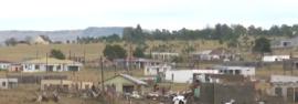
A sudden and unexpected tornado ripped through parts of Pinellas County on Wednesday, leaving a trail of destruction as it damaged dozens of homes in neighborhoods west of Tampa.
The area witnessed a severe thunderstorm moving through in the early evening before it suddenly spawned a twister that tore through mobile home communities in the Pinellas Park area.
Video footage captured by locals showed a terrifying swirl in the sky as debris flew around in Largo.
The tornado ripped siding and pieces of roofs from structures. Power outages ere also reported across the county.
Emergency crews went door-to-door to check for potential victims but no significant injuries have been reported. "At this time, no injuries have been reported; however, multiple homes have sustained damage. We ask the public to avoid the affected areas to allow emergency crews to safely and effectively continue their work," the Largo Police Department stated.
By nightfall, emergency crews were working to clear debris from streets as residents were urged to stay away from the damage zone. The storm also produced hail ranging from pea size to quarter size, according to the National Weather Service office in Ruskin.
Local emergency management officials and NWS meteorologists are expected to survey the damage on Thursday.
South Florida will continue to experience elevated chances of rain as well as some isolated severe storms on Thursday and Friday. The biggest threat to the region will be strong winds.
Thursday and Friday morning could both start with storms, but there will likely be a break for much of the morning before the rain ramps up in the afternoon each day, with downpours and a few strong storms expected.
On Thursday, the chance of precipitation is 40%. Temperatures will reach highs near 90 and there will be a 5 to 10 mph Southeast wind. On Friday, rain chances will increase to 50%. Conditions will be partly sunny with a high near 90 again and Southeast winds of 5 to 10 mph.
By Saturday, the chance of precipitation will drop to 30% and it will be mostly sunny.

Florida has already witnessed several large plumes of Saharan dust this year but another dust cloud has been making its way to the region and is set to move into the Sunshine State, peaking on Saturday.
As the dust plume brings dry air it will allow rain chances to drop off for one day. While there is currently some widely scattered storms in the region, it may become very dry and very hazy if the dust plume settles right over the area.
The tropics are also set to remain quiet for the next week.