Hurricane season is less than two weeks away, beginning on June 1 and running through Nov. 30, and forecasters are monitoring key trends that may signal an active start to the season.
While many factors help determine the season’s level of activity, two important indicators are trending in a direction that may lead to more and/or stronger storms:
An early season heat dome recently caused sea temperatures in the Gulf of Mexico and Caribbean Sea to warm well above average.
Meanwhile, strong winds in the equatorial Pacific Ocean have churned cooler waters from below through a process called upwelling, implying a slight shift in a La Niña-like direction.
La Niña events typically enhance hurricane activity in the Atlantic.
While it’s uncertain whether recent strong winds will continue and culminate in a full-fledged La Niña later this year, the latest trends suggest that wouldn’t be a huge stretch.
Based on these trends, hurricane-prone areas should be ready for a storm sooner rather than later.
On average, hurricane season features 14 named storms, including seven hurricanes and three that reach Category 3 or higher.
The first named storm typically forms by June 20, with the last 10 seasons all featuring at least one storm before that date. The first storm this season will be named Andrea.
Seasonal outlooks for hurricane activity suggest that there may be slightly more storms than normal this year but fewer than last year, partly because of changes in ocean temperatures. While waters in the part of the Atlantic where many storms form are warmer than average, they aren’t as warm as last year, which featured swaths of record ocean heat.
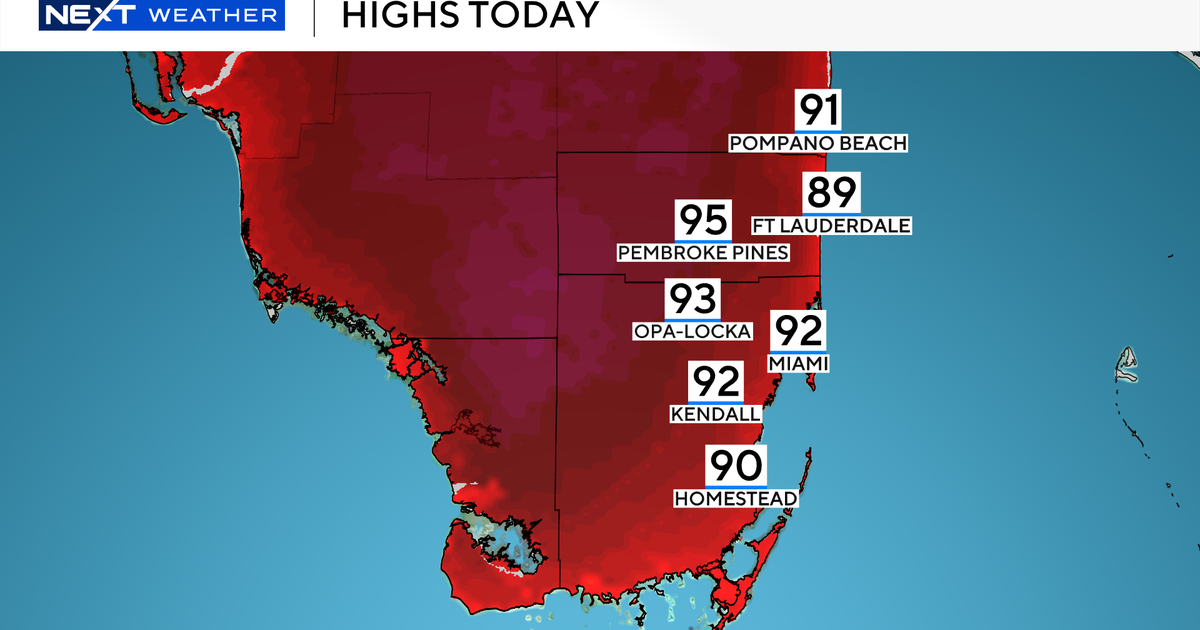
However, a heat dome that recently brought record temperatures to southern states also heated the Gulf of Mexico and Caribbean Sea — the same areas where early-season tropical storms and hurricanes tend to form.
During April, the upper 1,000 feet of ocean water across the Gulf of Mexico were 10th-warmest on record since recordkeeping began in 1958. At this time last year, it was 19th-warmest.
And now, a heat dome over the region has warmed waters further.
The warm water can fuel early-season storms. It can also enhance the amount of moisture that can fuel storms like the deadly atmospheric river that struck the Mid-Atlantic last week.
Following sharp ocean warming near South America earlier this year, La Niña was declared over, and a pattern of neutral conditions in the Pacific was said to have arrived.
But now, waters in the equatorial Pacific are gradually cooling, something that was unlikely according to most climate models. These cooler conditions become more noticeable when using an El Niño and La Niña measuring index that accounts for how warm or cool the Pacific is relative to other oceans.
While this cooling doesn’t necessarily mean that another planet-cooling La Niña is on the horizon, it may give the Atlantic hurricane season a boost later this year, particularly if it continues.
Cool water in the Pacific means that the region is less conducive to thunderstorm activity. When thunderstorms form, their exhaust, called outflow, can jump over to the Atlantic, making make it more difficult for hurricanes to form and strengthen there.
But if there are fewer thunderstorms in the Pacific because of cooler waters, it’s unlikely to be a major barrier for hurricane formation in the Atlantic.
As hurricane season approaches, no storms are on the immediate horizon for the Atlantic.
However, a storm-sparking cluster of rain and thunderstorms that regularly rotates across the global tropics could reach the Atlantic during June. It will first reach the tropical eastern Pacific, where hurricane season started on May 15, potentially spawning a storm.
University of Miami meteorologist Andy Hazelton wrote that storm formation is possible in the Atlantic toward the middle part of next month.
In the meantime, residents in hurricane-prone areas should continue to plan and prepare for the season ahead, as it doesn’t necessarily take a strong storm to have a devastating impact — particularly in a warmer world where storms can transport more water vapor.