Tornado watch for areas north of Indianapolis - NewsBreak
<fuel-video plugin-version="3.6" id="fuel-single-post-player" class="single-fuel-player" title="Late-night weather forecast with Drew Narsutis | May 15, 2025" video-url="https://fuel-streaming-prod01.fuelmedia.io/v1/sem/d8de0f07-6f2e-4edc-98c5-f05a04a5038b.m3u8?swc=9d1f2b10-f865-4eb3-99d0-fbb1fb4ed17c" data-poster-image="https://www.wishtv.com/wp-content/uploads/2025/05/16/1390390_thumbnail.png" data-audio-and-autoplay="1" preload="auto" data-swc="9d1f2b10-f865-4eb3-99d0-fbb1fb4ed17c" data-channel="d8de0f07-6f2e-4edc-98c5-f05a04a5038b"></fuel-video>" class="fuel_embeded_code_1390390">
Interactive radar | Storm Track 8 weather app | Watches & warnings | Hourly forecast | Wind gusts
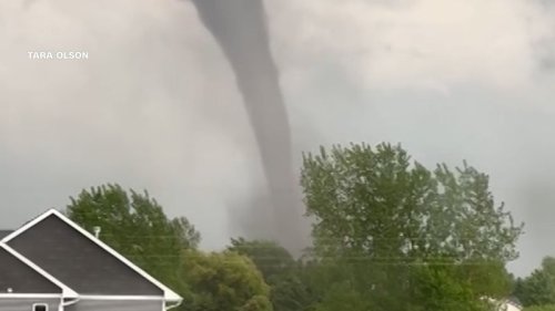
INDIANAPOLIS (WISH) — Parts of northern and north central Indiana are under a tornado watch until 3 a.m. Friday, the National Weather Service announced Thursday night.
However, by 11 p.m. Thursday, the watch was being scaled back, dropping dozens of counties as the severe threat lessened.
As of 11 p.m., cities under the watch included Logansport, Marion, Plymouth, South Bend and Warsaw. Counties under the watch were Elkhart, Kosciusko, Lagrange, La Porte, Marshall, Noble and St. Joseph.
The watch does not include the Indianapolis area.
Primary hazards are a couple of strong tornadoes, hail up to the size of tennis balls, and scattered gusts up to 75 mph.
Indiana was under two tornado watches. The other watch, through 11 p.m. Thursday, included five Indiana counties — Benton, Jasper, Lake, Newton and Porter — as well as much of the Chicago area in Illinois. Severe thunderstorms were already moving through the area at 9 p.m. Thursday.
Storm Track 8 expects Friday to have more severe weather from 5-11 p.m. in Indiana. Multiple storm clusters are possible, with discrete cells less likely but not totally out of the question. Overall, numerous to widespread strong-severe storms could evolve.


:max_bytes(150000):strip_icc()/GettyImages-1061685262-ede074270422423a9d9d7bf89ead59bc.jpg)