Threat of large hail, destructive winds and possible tornadoes heightened Sunday across North Texas - CBS Texas
/ CBS Texas
Heat and severe storms to settle across North Texas, prompting possible warnings
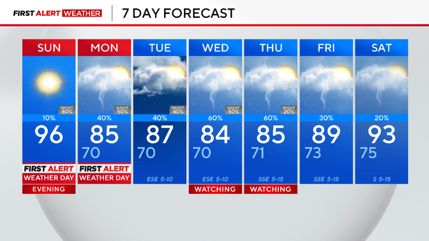
A First Alert Weather Day is in effect Sunday for heat index values in the triple digits, as well as a significant threat for large hail, tornadoes and destructive winds Sunday night.
Environmental factors are extremely favorable for storm development. There is a sufficient amount of moisture, instability and warmth ahead of a potent front. The cold front will tap into an abundance of convective available potential energy, CAPE, which will ignite numerous severe storms.
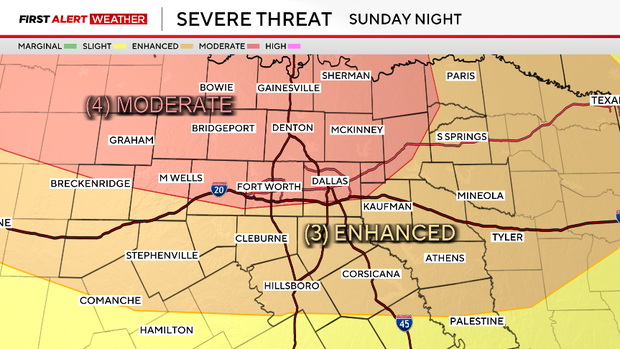
The Storm Prediction Center highlighted aModerate Risk, level 4 out of 5, indicating the confidence is high for widespread severe weather Sunday night. There is a significant risk for wind and hail.
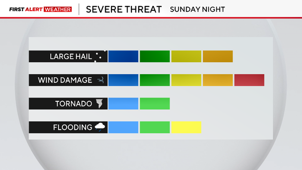
A significant wind threat means that winds 70 mph or stronger will be a possibility. To put this into perspective, these straight-line winds could get up to category 1 hurricane strength.
In addition, there is a significant hail potential, meaning hailstones larger than golf ball size are also a threat.
Though wind and hail are the primary risks, there is still a chance for tornado development and flooding.
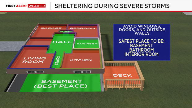
The severe weather forecast is particularly dangerous because it is overnight. It is crucial that you have multiple ways to get alerts and have a safe place to take shelter in advance. A good place to take shelter is an interior room at the lowest level of a sturdy building.
Unfortunately, cars and mobile homes are unsafe to be in during severe weather.
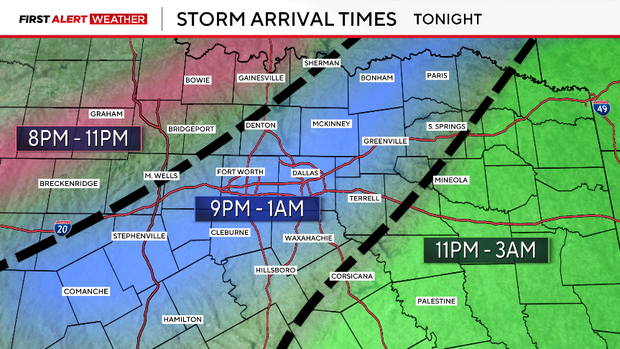
As of Sunday morning, the forecasted storm timing looks to be around 7 p.m. to 3 a.m. for North Texas. The Dallas-Fort Worth metroplex timing looks to be around 9 p.m. to midnight.
After the front passes through North Texas, more storms will remain possible on Monday. Any additional heavy rain will lead to a big flood risk, hence another First Alert Weather Day is in effect Monday. The weather pattern continues through next week.
Tune in Sunday night for severe weather coverage with Chief Meteorologist McKenna King and Meteorologist Jeff Ray.