Summer-like heat briefly returns to Northern California before weekend cooldown - CBS Sacramento
/ CBS Sacramento
Wednesday afternoon weather forecast - 6/18/2025
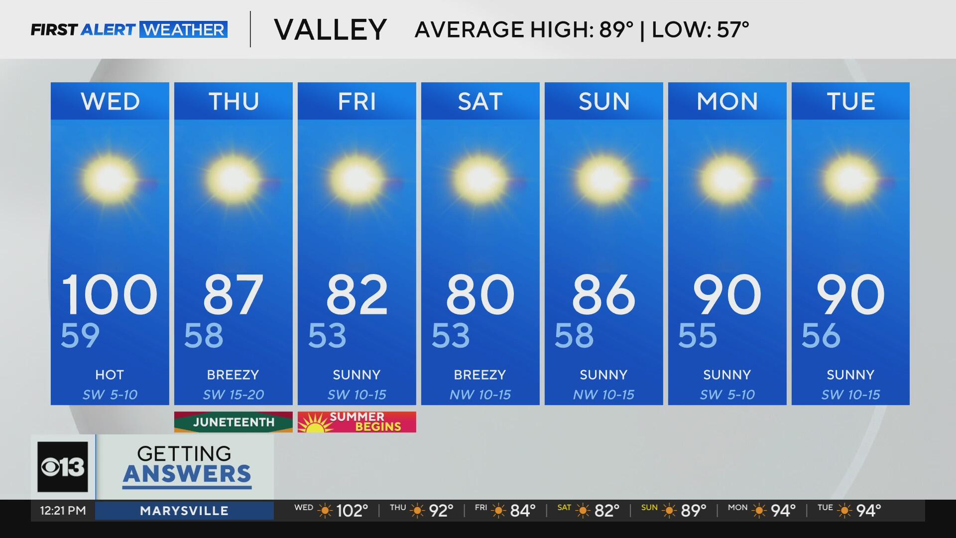
Triple-digit heat is back in the forecast Wednesday, but it'll be short-lived as our next pattern change brings cooler air and strong winds by the end of the week.
The hottest day of the week arrives on Wednesday as a high-pressure system spreads over California.
Valley temperatures will soar into the triple digits by late afternoon, with Sacramento expected to hit 100°F for the first time this June.

The heat will also impact the foothills, where highs will climb into the upper 90s and low 100s.
Even the Sierra will feel warm, with sunny skies and highs in the 80s. A noticeable shift after a mild start to the month.
By Wednesday night, a light Delta Breeze will begin to pick up, setting the stage for a noticeable cooldown Thursday morning across the Sacramento and San Joaquin Valleys.
Our high-pressure system won't stick around long. By Thursday, it begins to shift east, making way for a strong low-pressure system moving toward the West Coast. This will deepen the marine layer and usher in cooler, windier conditions through the end of the week.

While rain is expected in the Pacific Northwest, our region will stay mostly dry. However, fire danger will remain elevated due to gusty winds and dry vegetation, especially in grassy and wooded areas that have been drying out in the recent heat.
Thursday kicks off with morning temperatures in the 60s, rising only into the mid to upper 80s by the afternoon, a 20+ degree drop from Wednesday.

Winds will also pick up, particularly in the Delta and Sierra regions, where a Red Flag Warning is in effect from the Tahoe Basin into parts of Nevada.

In the Valley, wind gusts could reach up to 35 MPH by Thursday evening. While higher humidity levels may prevent critical fire conditions, fire danger remains high. Be cautious around dry brush and practice fire safety.

PG&E issued a Public Safety Power Shutoff warning for parts of Northern and Central California from Thursday through Sunday.
We'll end off the week in the 80s as highs on Friday.
The Summer Solstice officially begins at 7:42 p.m. on Friday, June 20, marking the longest day of the year and the official start of summer.
Expect gusty conditions Friday, especially in the Delta and mountains, where winds could reach up to 50 mph. If you have outdoor plans, be mindful of the wind and fire danger.

Heading into the weekend, our cool down continues. Valley temperatures will hold in the low 80s, while foothills and mountain areas will feel a significant drop, with highs in the 60s and 70s.

In fact, Saturday, the first full day of summer, will be the coolest day of the week.
Next week will begin mild with highs in the upper 80s to low 90s. We'll add in more heat by Wednesday, yet highs will stay close to seasonal averages.
Make sure to stay with the CBS Sacramento First Alert Weather team for any new updates.