Rare dust storm warning for Chicago area from gusty storms
A rare dust storm warning was issued for much of the Chicago area Friday night as fast-moving wall of dust blanketed the city and suburbs in a thick haze.
The National Weather Service's Chicago office confirmed it was only the second time in its history that it has issued a dust storm warning. The first time was on May 7, 2023, but that warning did not involve the Chicago metropolitan area. Friday's warning was the first dust storm warning that included the city itself.
The dust storm blew through as scattered showers and thunderstorms were moving through northern Illinois and northwest Indiana. The National Weather Service said it was the result of 60 to 70 mph winds that blew over dry farmlands, collecting dust into the air, and blowing it through the Chicago area.
Multiple dust storm warnings were issued as a wall of dust moved through the Chicago area, but have since been cancelled or expired.
The National Weather Service said the dust storm caused significantly reduced visibility on Interstate 55 near Shorewood, Interstate 57, and Interstate 80 near Joliet, along with Interstate 65 near Crown Point, Indiana.
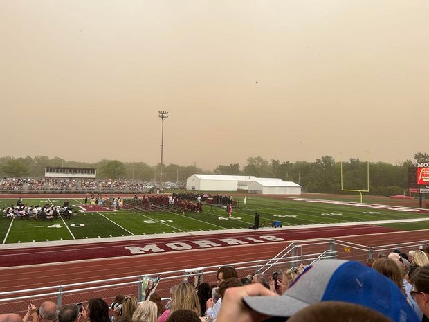
The literal wall of dust blowing through the Chicago area quickly dropped visibility to almost zero as the dust storm blew through. Visibility dropped noticeably in downtown Chicago shortly before 7 p.m., but had mostly cleared up again by around 7:30 p.m.
In Kankakee County, visibility was down to zero around 6:30 p.m., but was back up to 10 miles by 7 p.m.
The storms also prompted ground stops at O'Hare and Midway airports that have since been lifted.
As showers and storms in some areas hit at the same time as the dust storm, there have been reports of almost a "mud rain."
According to the National Weather Service, wind gusts could reach over 70 miles per hour during the storms.
The most significant storm threat remains east of I-55.
Cooler, dry weather settles in this weekend, but a rainy pattern returns next week. Early projections show that we may total 1" to 1.5" of rain Monday night through Wednesday morning.
Cooler and dry weather will then settle in for the weekend.
A small number of schools announced closures Friday due to power outages in the wake of Thursday's severe weather events.
As of 7:30 a.m. Friday, Crown Point Community School, Lake Station Community Schools and Manhattan District #114 had all reported closures.
There will be no on-site and e-learning at Arbor Park School Distirct #145 due to power and internet outages.
Summer-like conditions continue as highs reach near 90 degrees.

Winds remain strong into the night and Saturday. Click here to see our full seven day forecast.
Todd Feurer is a web producer for CBS Chicago. He has previously written for WBBM Newsradio, WUIS-FM and the New City News Service.
Laura Bannon contributed to this report.