Nice weather on Saturday; cooler, breezier, and wetter on Sunday
We are going to have partly to mostly cloudy skies tonight with a few showers around, generally in locations east of I-15. It is also going to be cool tonight as lows are going to be in the 30s and low to mid 40s.
Tomorrow will be the sunnier, warmer, drier, less windy, and overall nicer day of the weekend. If you want to do anything outdoors this weekend, I recommend that you do it tomorrow! We are going to have a mixture of sun and clouds tomorrow with the cloud cover increasing as the day goes on. There will be a few showers and isolated thunderstorms around tomorrow, but a lot of locations will be dry. It is also going to feel great outside tomorrow as highs are going to be in the 60s in most locations. There is also going to be little to no wind in most locations tomorrow, but it will be breezy in portions of Phillips County and Valley County.
Rain showers will become more numerous as we go through tomorrow night in central and western Montana as a storm system begins to impact our area. Sunday will be a cloudy and wet day as rain showers are likely throughout the day, with snow showers in the mountains. Some of the precipitation that falls Saturday night and Sunday will be moderate to heavy at times. A few isolated thunderstorms are also possible tomorrow night and Sunday.
Rain and mountain snow will continue to fall Sunday night, primarily in locations east of I-15. Moderate to heavy precipitation will also be possible at times Sunday night. Snow levels Sunday night into Monday morning may get as low as about 5500 to 6000 feet, so a few mountain passes may be slushy for the Monday morning commute. On Monday, we are going to have partly to mostly cloudy skies with a few morning rain showers around and west of I-15. East of I-15, rain showers are likely on Monday, but these showers will gradually taper off as we head into the afternoon and evening. Overcast skies are also expected east of I-15.
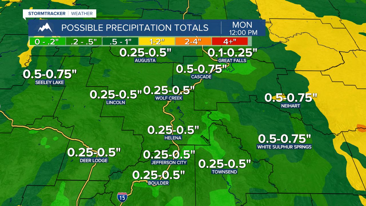
This will be a good soaking rain for a lot of north-central and central Montana. Through midday Monday, .25” to 1” of precipitation is expected for a lot of north-central Montana. There are also going to be some areas in north-central Montana that receive 1-1.5+" of precipitation. There is still some uncertainty on where this heavier precipitation will fall, but these higher rainfall amounts will likely be focused over central and/or eastern portions of north-central Montana. Around the Helena area, .1” to .5” of precipitation is expected, with a few areas receiving up to .75” of precipitation. In the mountains, a few inches of snow is possible above 6000 feet.
It is also going to be cool on Sunday as highs are only going to be in the mid to upper 40s and low to mid 50s. Gusty winds are also expected on Sunday as sustained wind speeds are going to be between 10 and 30 mph, and wind gusts over 40 mph will be possible at times. On Monday, it will be a little bit warmer, but still cool, as highs are going to be in the 50s and low 60s. There is also still going to be a breeze around in some areas on Monday as sustained wind speeds are going to be between 10 and 20 mph.
Unsettled weather will stick around for the rest of next week, although next week will not be as cloudy, wet, or cool as this week was. Daily chances of showers and isolated thunderstorms are expected from Tuesday through Friday, but no significant precipitation events are expected. We are also going to have partly to mostly sunny skies and seasonable temperatures from Tuesday through Friday as highs are going to be in the 60s and upper 50s in most locations. Breezy conditions are also expected on Tuesday and Wednesday as sustained wind speeds are going to be between 10 and 25 mph.


Copyright 2025 Scripps Media, Inc. All rights reserved. This material may not be published, broadcast, rewritten, or redistributed.