May 14, 2025 Wednesday Weather
The heat forecast across Texas is complicated with the advance of the dry line vs. moisture from the Gulf around Austin. Looking at the forecast model trend (ECMWF) over the past several days for today (Wednesday), we’ve gone from 111°F as the most extreme solution from a few days ago to now 101°F. NWS is at 104°F in the forecast grids this morning.
Another thing to point out: when should you have known that Austin was going to hit 100°F or higher on Wednesday, May 14th? In other words, the forecast horizon allowed you to see the solution for today — 7 to 8 days ago when upper-90s showed up in the ECMWF HRES model.
Precipitable water today shows the moisture overspreading eastern half of Texas this afternoon, but missing Dallas / Fort Worth until later, allowing for more extreme heating. Dallas temperature > Austin is an interesting bet for today!
ECMWF has been insistent on 105°F to 107°F for DFW for the past several days. NWS is at 100°F.
For comparison and another opinion, GFS is at 103°F for the DFW grid cell, and has been locked in for the 6-days.
(One of my favorite parameters to show the evolution of weather patterns)
First, not seeing any tropical storm development in the next 10-days. We are looking at Central America on both sides — as the potential for monsoon gyre enhanced vorticity to spin up into a tropical system over the warm waters of the Eastern Pacific or Caribbean.
We do see at the end of the loop a surge of moisture transport approaching Nicaragua and crossing into the EPAC.
You can also see how the Gulf of Mexico ridge redirects moisture plumes around its periphery into the Mississippi River Valley and into the storm system over the Midwest. Tapping into the moisture plumes = atmospheric rivers and heavier precipitation, assuming the Gulf of Mexico is opened for business. A strong deep-layer ridge does the trick!
Very dusty across the Eastern Tropical Atlantic — a situation we’ll see for the next 1-2 months with ebbs and flows of the Saharan Air Layer (SAL) interspersed with tropical waves. The tropical storm season out here cranks up in July.
The Main Development Region (MDR) from the Lesser Antilles to the coast of Africa has a discernible SAL and dusty layer largely suppressing rain showers and storms due to stability.
Largely quiet across the Eastern Lower 48 with light showers across the Northeast including NYC. Clouds and dreary conditions will eventually break up.
A storm system is developing in the Rockies and northern Plains that will intensify into low pressure at the surface into the 980s mb and then occlude/mature over the Midwest swinging a warm front through the Great Lakes with chance of severe weather on Thursday.
Scattered showers with the leftovers from the long-lasting cut-off low across the Mid-Atlantic and Northeast.
Slight chance of severe weather with our next storm system developing across the northern Plains.
with 264 million at least 70°F. 12 million in Texas at least 100°F
90s all the way into northern Minnesota and Manitoba today … connecting to the 100s into Texas including Dallas, Austin, and San Antonio. Hottest in Texas 113°F!
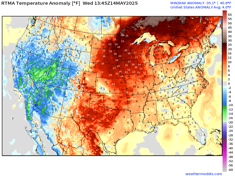
15°F to 20°F above normal in the central Lower 48 but much colder than normal across the Western U.S. including the Rockies.
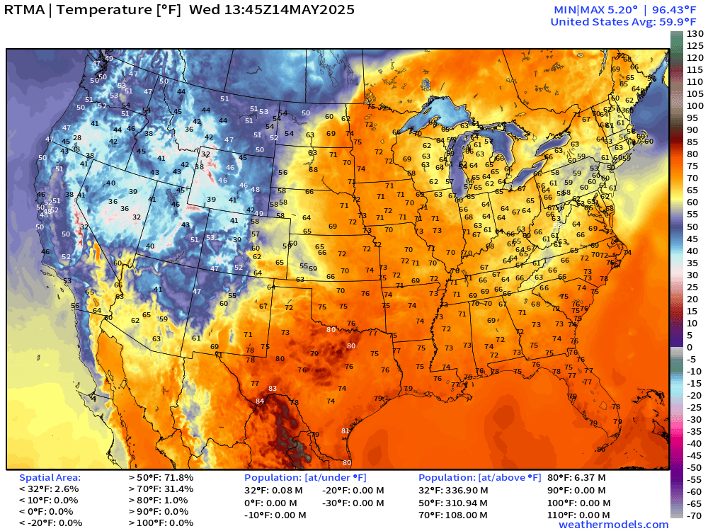
70s are quite popular this morning already, but only 30s in the Rockies. Tiny population below freezing.
Overall the
If you missed out on a coupon, then this link / button will provide annual upgrade at the previous $50/year.
The growth of this newsletter up the Leaderboard is key to expanding the maps and analysis to the wider Substack audience. While politics is king on this platform, I’m hopeful that thoughtful data viz and weather + climate can break through the noise.