Hurricane season 2025 prediction: Key factors that could influence tropical activity ahead of NOAA's predictions - ABC13 Houston
The countdown is on for the start of the 2025 Atlantic Hurricane season, which begins on June 1 and lasts through the end of November.
After a record season for the Gulf Coast in 2024, which included hurricane Beryl making landfall in southeast Texas, ABC13 Meteorologist Elyse Smith has a preview of what to look out for this year.
Let's start with the El Niño, or La Niña. This hurricane season is more than likely going to be an ENSO neutral year, or a "La Nada." This means the Trade Winds over the Atlantic are in their usual position at normal strength. There's no major influence on jet stream patterns or ocean temperatures like there would be during an El Niño or La Niña. The other top driver will be ocean temperatures, as it is every year. The warmer the water, the higher the likelihood for storms to develop and intensify.
Storm development can depend on the status of the West African Monsoon. That's what sends clusters of thunderstorms to the Atlantic, which can then become a tropical system. What can limit that from happening is Saharan Dust, which usually occurs earlier in the season. So, when it comes to storms that could threaten southeast Texas, local weather patterns and those over the Caribbean can be the final factor. If the jet stream is over the Gulf, there's higher wind shear that can weaken tropical systems.
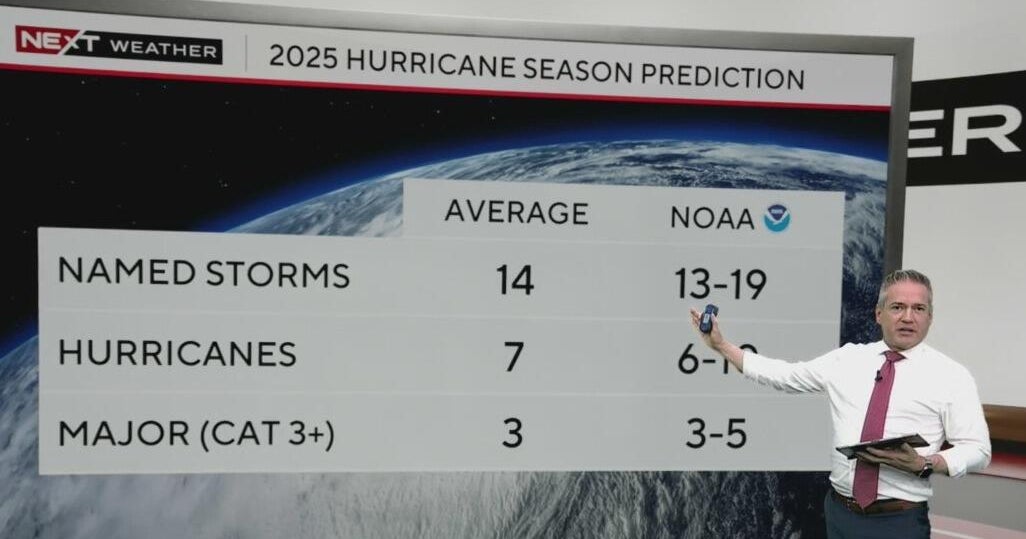
That said, the 2025 Atlantic hurricane season could be an active one with above-normal activity across the tropics. While the 2025 outlook from NOAA is set to be released this Thursday, researchers with Colorado State University released theirs last month. It also reflects the above normal prediction, calling for 17 tropical storms, nine becoming hurricanes, and four potential major hurricanes.
Another way to preview an upcoming hurricane season is through analog years. These are past years which, based on similar atmospheric conditions, could be comparable to what this season might look like. Dr. Phil Klotzbach with Colorado State University told ABC13 Meteorologist Elyse Smith that these years are 1996, 1999, 2006, 2008, 2011, and 2017.
Some of these years will stand out to Texans, and for good reason: 2008 for Hurricane Ike and 2017 for Harvey. However, consider 2006 and 1999, which were very different seasons for the Texas coast. 2006 was a slightly below normal year in terms of the number of storms, and no hurricanes made landfall in the U.S. Tropical storms did hit Florida that year. 2011 was active for the Atlantic and Bay of Campeche, but not necessarily the Gulf.
One thing worth mentioning, we don't know how the recent cuts to NOAA will impact operations during hurricane season. While outlooks and forecasts will still be issued in a timely and accurate manner, one curveball could be associated with the hurricane hunters, the possibility of or frequency of their flights, and any research planned to occur during this hurricane season.
For more on this story, follow Elyse Smith on Facebook, X and Instagram.
Copyright © 2025 KTRK-TV. All Rights Reserved.