'Hazardous': Warning as cities hit by massive dust storms, destructive winds | The West Australian
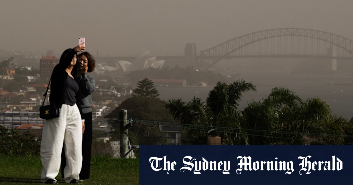
Thousands have woken to a sea of yellow and red as an enormous dust cloud that blanketed South Australia and parts of Victoria is dragged over to Sydney and the South Coast.
The Bureau of Meteorology issued a weather warning to residents in Sydney on Tuesday morning after strong westerly winds left Sydney Harbour blanketed in yellow dust.
Air Quality NSW has warned of “hazardous” air quality in Parramatta North and “extremely poor” air quality in Albion Park South, Kembla Grange, Wollongong and Bargo as particle levels (PM10) exceed 600.

Particles in the air can include “dust or sea salt, as well as smaller particles generated from combustion processes such as vegetation fires, motor vehicles and industrial sources”, the website reads.
“These particles can pass into the lungs. Short-term impacts include difficulty in breathing and worsening of asthma or chronic bronchitis symptoms. They can also cause irritation of eyes, nose and throat.”
Areas in western Sydney, such as Penrith, Oakdale, Richmond, Rouse Hill, Prospect and Macquarie Park, have been issued “very poor” air quality, and residents are advised to reduce physical activity outdoors and close windows until the air quality improves. “If you feel that the air in your home is uncomfortable, consider going to a place with cleaner air (such as an airconditioned building like a library or shopping centre) if it is safe to do so,” the website reads.

As thousands of NSW residents continue the mammoth clean-up efforts following last week’s devastating floods, conditions are yet to ease for much of the state, with blistering and damaging winds smashing the Northern Tablelands and already affected areas of the Mid North Coast.
“We do have damaging wind warnings current for much of the ranges of NSW,” senior meteorologist Dean Narramore said.

Winds gusts could exceed speeds of up to 90km/h, he said, especially through the Barrington Tops, Northern Ranges and all the way to the Snowy Mountains.
Sydney is not immune to the winds either, with gusts reaching up to 45km/h in the city, dragging dust from the country’s southeast and blanketing parts of the city in hazy yellow and orange.
However, these windy conditions are set to ease by Tuesday evening before picking up again on Thursday.
It will also be a wet day for pockets of NSW on Tuesday, with 20mm-40mm of heavy rainfall through parts of the Hunter and northern NSW region recorded on Tuesday. “That will clear off,” Mr Narramore said.

Red dust swallowed parts of South Australia as wild weather whipped up dirt across the state on Monday, May 26. Footage posted by District Council of Orroroo Carrieton shows an intense red haze smothering the town of Orroroo. The Bureau of Meteorology issued a severe weather warning for much of southeast Australia with reports of gusty winds reaching up to 126 km/h (78.2 mph). The windy conditions were expected to push through to Victoria and New South Wales later in the week. Credit: District Council of Orroroo Carrieton via Storyful
The warning comes as thousands of residents in South Australia and parts of western Victoria were swallowed by a massive dust storm on Monday, with red and orange clouds rolling through the streets and reducing visibility to as little as 300m.
Winds reached speeds of 107km/h in Maitland and more than 100km/h in Cape Border and Cummings overnight.
There was also a welcomed spot of rain in the state, with 30mm-50mm in the Mount Lofty region and 55mm on Maidment Rd in Adelaide Hills. More than 3000 residents remain without power on Tuesday as the storms ripped through the state, tearing down trees and power lines.
Students at the Marcellin Campus at Sacred Heart College were told to stay home on Tuesday after the storm brought down power lines and presented a “significant safety risk”.
“Powerlines are down on Cudmore St which poses a significant safety risk,” a school statement read. “Accordingly, Marcellin Campus is closed today until further notice.” A severe weather warning was issued for the Flinders Ranges in South Australia, about 200km north of Adelaide, with “dangerous’ wind gusts reaching speeds of up to 90km/h.

However, Mr Narramore said the conditions across SA would be “much calmer” on Tuesday than the day before, with isolated showers across the southern coastal regions of the state. “Most of that weather will clear out by the time we get to this afternoon and this evening as high pressure moves in,” he said.
The wild dust storm also hit parts of western Victoria, including Mildura, which was inundated by the enormous red clouds. Cars were forced to pull to the side of the road while the dust settled and visibility improved.
In Victoria, conditions will be wet for much of the southern and mountain regions as winds shift to a south-westerly direction, bringing a cold snap to the elevated parts of the Alpine region.
Across the country, residents will be in for a wet and windy day in many cities,
Brisbane can expect a cloudy day with a slight chance of a shower, strong winds reaching speeds of 45km/h and a top temperature of 29C.
Sydney will reach a top of 19C with strong winds and partly cloudy skies.
Melbourne residents can expect a high chance of showers in the afternoon and evening, strong winds and a maximum temperature of 16C.
There is a medium chance of showers for Adelaide, with partly cloudy skies and a top of 18C.
Hobart has a high chance of showers and westerly winds, reaching a maximum temperature of 15C.
It will be sunny and clear for Perth, with north-easterly winds and a top of 21C.
Canberra will be cold and wet with a high chance of showers and a maximum temperature of 12C.
Darwin will be hot and partly cloudy, with showers in the evening and a top of 31C.