Drier, calmer end to week in Minnesota before spotty storms return this weekend - CBS Minnesota
By
Born and raised in Pittsburgh, Pennsylvania, weather has been a passion for Adam for as long as he can remember! Whether it was thunderstorms or winter storms, Adam has always been geeking out. After earning his meteorology degree from Penn State, he made his way to the Ohio Valley to forecast for WTOV.
/ CBS Minnesota
NEXT Weather: 5 a.m. report on June 27, 2025
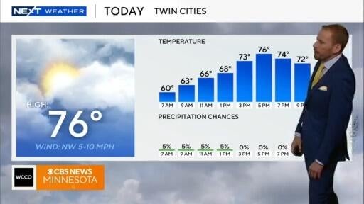
Friday starts with some fog and low clouds in the Twin Cities, but there will be noticeable improvements later in the day in the form of a little sunshine as high pressure briefly builds in.
Even with some clouds sticking around, this will help start warming temperatures, with afternoon highs more seasonable in the mid 70s.
We'll notice more heat and humidity building through the weekend, adding some instability ahead of a wave of upper level energy that will slide in from the Dakotas.

This will bring a chance for storms both Saturday and Sunday, possibly severe with wind and hail the main concerns, especially later Saturday.
Expect high temps in the upper 80s on Saturday and a degree or two cooler Sunday.
High pressure is back early next week. making for a sunny, seasonable start to the week.
It looks like things turn stormy again toward the end of the week with several chances for storms as we approach the Fourth of July.
Born and raised in Pittsburgh, Pennsylvania, weather has been a passion for Adam for as long as he can remember! Whether it was thunderstorms or winter storms, Adam has always been geeking out. After earning his meteorology degree from Penn State, he made his way to the Ohio Valley to forecast for WTOV.