California storm threatens LA fire areas with flooding and debris flows as winter storm delivers snow to the Midwest | CNN

CNN —
Southern California’s most significant storm in more than a year is incoming, stoking fears of life-threatening debris flows in the Los Angeles area torched by historic wildfires last month.
It’s just one of three winter storms this week brought about by a hyperactive weather pattern that’s been slamming the US with snow, ice and rain since the start of the month – another storm is currently hitting the Plains and Midwest with heavy snow.
Evacuation warnings have been issued in Southern California in areas burned by recent fires, and other preparations aimed at preventing debris flow disaster are underway before the worst conditions from California’s storm arrive Thursday.
Here’s the latest:
The upcoming storm will be the “most significant” so far this winter in Southern California and will bring “very intense” rainfall, warned Ariel Cohen, a meteorologist with the National Weather Service in Los Angeles.
Some rain will impact Southern California Wednesday but it will be much lighter in nature than what’s to come Thursday.
Portions of California’s Los Angeles and Ventura counties — including areas burned by the Palisades and Eaton fires — are under a Level 3 of 4 risk of flooding rainfall Thursday, according to the Weather Prediction Center. More than 36 million in the rest of the state are under a level 2 of 4 risk of flooding rainfall Thursday. The threat area encompasses San Francisco, Sacramento, San Diego and areas in between.
Heavy rain presents an even greater risk to areas burned by recent deadly wildfires. An evacuation warning has been issued for those in “areas within and near the Lake Fire burn scar” in Santa Barbara County the Sheriff’s office said Tuesday.
“Given the elevated chances for significant debris flows consisting of raging torrents of rockslides and mudslides that can be damaging and even deadly, now is the time to start getting prepared for these potentially dangerous conditions,” Cohen urged in a news conference Tuesday.
The threat to the burn scar areas comes as officials are tackling the effort to remove hazardous debris left behind by the fires. Los Angeles County recently bolstered storm preparations by cleaning debris basins, installing concrete barriers, and placing sandbags in fire zones to filter debris and protect storm drains.
More than 7,500 feet of concrete barriers and more than 6,500 sandbags have been deployed to areas burned in the Palisades Fire in case of debris flows, Los Angeles Mayor Karen Bass announced Tuesday. Similar protections for the Eaton Fire burn scar were ongoing, according to California’s Office of Emergency Services.
Thursday’s flood risk will not be confined to areas scorched by wildfires.
“Even outside of the burn scars, we’re looking at the potential for some pretty significant urban area flooding,” Cohen warned.
This storm will dump 1 to 3 inches of rain over the Los Angeles basin and totals could approach 6 inches in the area’s mountains — including the burn scar of the Palisades Fire. This is the most rain in the area from a storm since last year’s extensive flooding and mudslides in and around Los Angeles.
“Of course we’re concerned about the Palisades and the burned areas, but this is for all of Los Angeles to be concerned about the rain and the impacts,” Bass implored.
The heaviest bursts of rain from Thursday afternoon into early Friday morning could also be accompanied by damaging wind gusts. These winds will be capable of downing trees and power lines and blowing around debris.
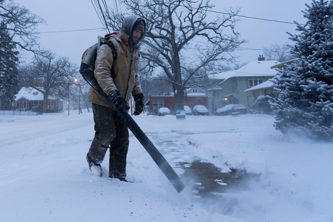
Another disruptive winter storm is underway in the eastern half of the US. Snow from a new storm that formed overnight in the Plains stretched from there to the Midwest Wednesday morning while a storm that first slammed the East Tuesday was still bringing rain and ice to parts of the region.
Wednesday’s storm will bring Chicago its most substantial snowfall so far this winter with up to 6 inches expected in the city. The typically snowy city should record two feet of snow by this point in the season but has barely picked up 7 inches since December. Double digit snowfall is possible north of the city, near the Illinois-Wisconsin border.
Schools in the Chicago area closed or shifted to online learning Wednesday in response to the storm. Public schools in Kansas City, Missouri, and several districts in Nebraska also closed.
Snow will reach parts of the Northeast Wednesday evening and last through much of Thursday. Ice will quickly start to mix in with the snow in parts of Pennsylvania and New York Wednesday evening and reach portions of New England overnight.
Ice will present a significant problem again just south of where the heaviest snow falls. At least a light glaze of ice — enough to make travel tricky — is possible anywhere from Oklahoma and Kansas through the Ohio Valley and Northeast through Thursday.
Parts of the Appalachians will get another round of ice from this storm. More than 170,000 homes and businesses were without power in Virginia Wednesday morning after ice from the first storm, according to PowerOutage.us.
Ice and more than a foot of snow wreaked havoc on travel in Virginia Tuesday. There were at least 305 crashes reported statewide. Injuries were reported in at least 24 of those crashes by Tuesday evening, according to state police.
A few of the locations hit hardest from Tuesday’s storm might not notice a break between the two storms as icy precipitation slows but doesn’t completely stop Wednesday afternoon.
Wednesday’s storm will reinvigorate rain and thunderstorms in the South.
Damaging storms are most likely in southern Mississippi and Alabama where a level 3 of 5 risk of severe thunderstorms is in place, according to the Storm Prediction Center.
Some thunderstorms could turn severe and generate a few tornadoes in an area from Louisiana to Georgia starting in the afternoon and lasting into the evening.
There is also the potential for a strong tornado – EF2 or stronger – or two in the most violent storms, the National Weather Service in Mobile, Alabama, warned Wednesday morning.
Some of these tornadoes could form after dark, making them even more dangerous. It’s difficult to spot a tornado at night, even for those who are awake or are awoken by warnings.
Nighttime tornadoes are twice as likely to be deadly as those that occur during the day, a 2022 study found.
A deadly tornado roared through a Tennessee community after dark just last week.
CNN’s Michelle Watson, Lauren Mascarenhas, Hanna Park and Stephanie Elam contributed to this report.