Weather shift for Western Cape, cold front to hit on Wednesday
An intense cold front is expected to make landfall on Wednesday over the southwestern parts of South Africa, bringing a significant shift in weather conditions across the region, the South African Weather Service (Saws) said.
According to Saws, the system is expected to result in heavy rainfall with a risk of localised flooding over the western parts of the Western Cape, especially in low-lying and poorly drained areas, on Wednesday and Thursday.
“Wet and slippery roads may result in dangerous driving conditions. Motorists should exercise caution and adhere to safety measures. Strong and gusty winds over the interior may cause localised damage to structures and uproot trees.”
Cold to very cold conditions can be expected, with possible snowfall, over the western mountain ranges of the Western Cape, spreading into the southwestern interior of the Northern Cape.
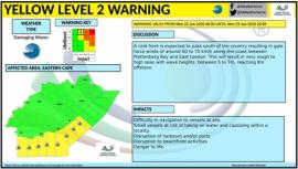
Gale force wind and rough seas, with wave heights between 5.5m and 7.5m, along the coastlines of the Northern Cape and Western Cape will lead to disruptions to fishing and port operations, an increased risk of vessels capsizing, accidents at sea and hazardous shoreline conditions.
Saws urged coastal residents and beachgoers to exercise caution.
It said that as the system progresses eastward it will affect the Eastern Cape, a region already vulnerable to weather-related impacts.