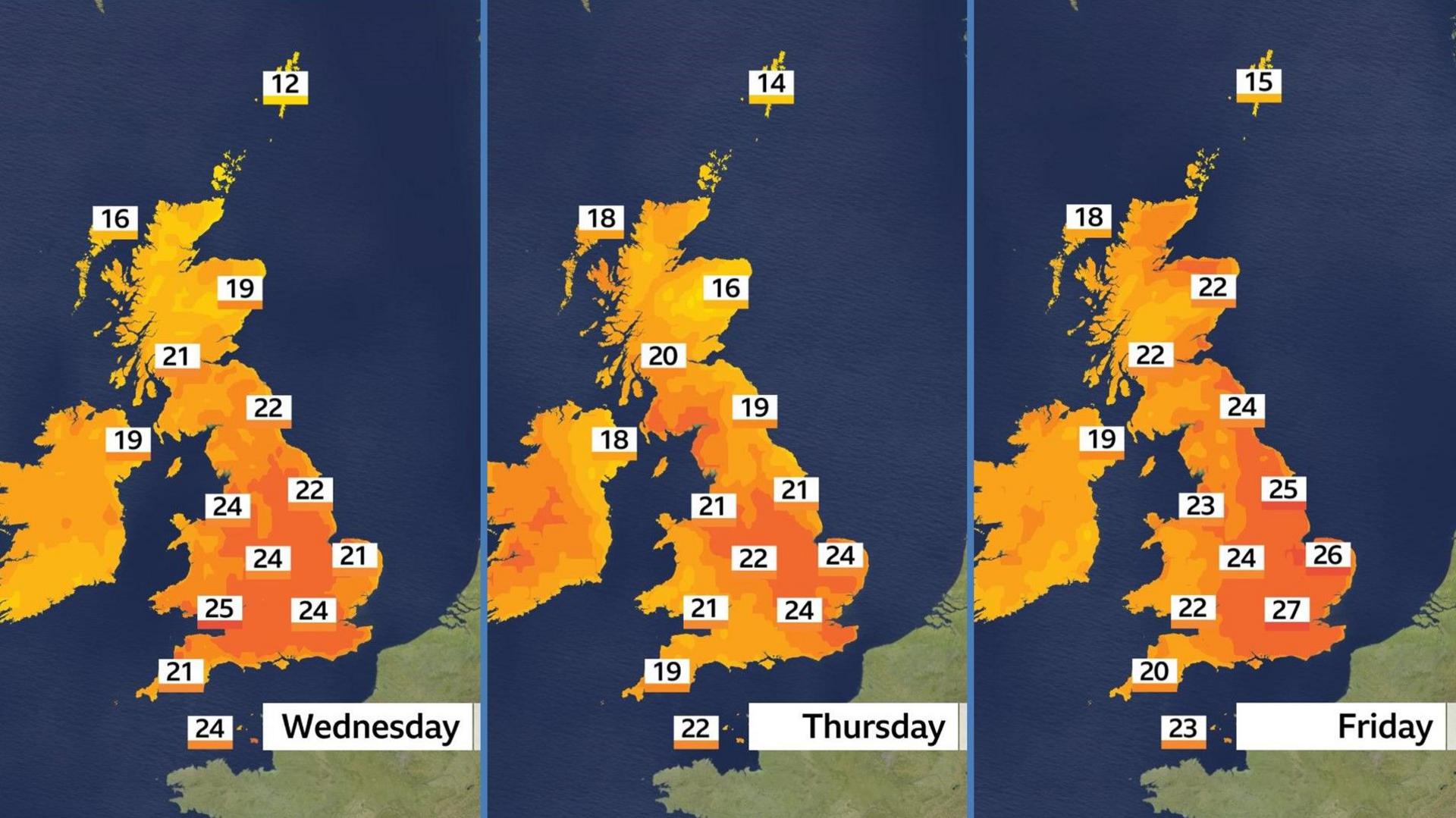
UK weather: Temperatures set to hit 29C this week with thunderstorms likely
Temperatures will start to climb on Tuesday but the really warm air will set in by Wednesday.
Most of Scotland and Northern Ireland will reach 18-21C (64-70F), with 21-25C (70-77F) expected across England and Wales.
The air will be turning increasingly humid, with a rather muggy and sticky feel.
Most places will be dry on Wednesday but during the afternoon and evening scattered showers and thunderstorms will start to develop in western parts of the UK.

A few places could reach 28C or 29C on Friday - with a low chance of 30C
The very warm and humid air will remain on Thursday but thunderstorms will become more widespread - which may suppress temperatures a little.
Very heavy downpours are possible, which could merge into longer spells of rain.
Friday looks likely to bring the peak of the heat with highs currently forecast to reach 27-29C (81-84F) in eastern England - with a mix of sunny spells and thunderstorms.
Some computer weather models suggest a low chance of reaching 30C (86F) if there is enough sunshine.
The nights will also be warm and humid which could make it a little tricky for sleeping.
At the moment it does not look like this will meet the official definition of a heatwave - three consecutive days above a threshold that varies from 25-28C (77-82F) in different parts of the country.
However it may well feel like one, especially given the humidity.
Maximum temperatures will be well above the seasonal average of 16-20C (61-70F) but are unlikely to threaten the UK's June temperature record of 35.6C (96.1F) set at Camden Square in London on 29 June 1957.
Keep an eye out for some impressive skies over the coming days.
This week has started with some vivid orange sunrises and sunsets due to wildfire smoke that has travelled across the Atlantic from Canada, high in the atmosphere.

Layers of smoke gave an orange hue to Monday's sunrise in Worcestershire
Later this week the southerly winds bringing warm air from north Africa are also expected to transport dust from the Sahara across our skies.
This could lead to further beautiful morning and evening skyscapes - especially when combined with layers of cloud.
If you capture any impressive sunrise or sunset photos, please send them to us at BBC Weather Watchers.
This week's warmth and humidity is likely to give way to something fresher over the weekend - although temperatures are likely to remain around or above the June average.
Beyond that there is a lot of uncertainty in computer weather models.
Some are suggesting the possibility of another surge of heat towards the end of the month, whereas others allow for cooler and more unsettled weather, especially in northern parts.
It is far too soon to predict the details of any heatwave that might head our way later this month - or deeper into the summer.
However, long-range forecasts do suggest a greater-than-normal chance of hot weather for the season overall.
You can always keep up to date with the changes in your local forecast with BBC Weather online and on the BBC Weather app.


