Strong storms and flooding will be possible today in the Pittsburgh area - CBS Pittsburgh
/ CBS Pittsburgh
KDKA-TV Morning Forecast (6/30)

Strong storms and flooding are possible today for parts of the Pittsburgh area.
Today is a First Alert Weather Day due to a flooding risk.
5.32" of rain has fallen in Pittsburgh this month, making it the wettest June since 2019.
Did you enjoy the one-day break from the rain? Rain and storm chances are back today with downpours potentially leading to flash flooding. We have already seen plenty of rain this month, 5.32" of rain at the Pittsburgh airport. This is already the wettest June since 2019. If we see 0.35" of rain today or more, we will end the month as a top twenty wettest June on record for Pittsburgh.
I have everyone seeing rain today, but most of your day will be dry. Most folks will see less than an hour total of rain.
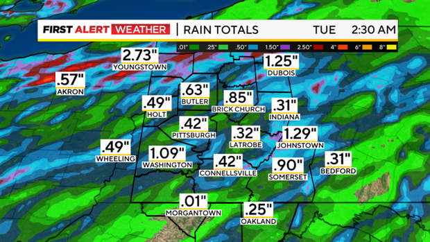
Storms may be intense though, with rain rates of 1.5" to 2" possible with the most intense. This means it would only take thirty minutes to see more than an inch of rain. With how saturated the ground is already, intense downpours, and topography that is conducive to flash flooding, the risk for flooding is marginal to slight. As always, if you see water on a road, just find another route around.The other issue today is that some of these storms will have a fast-moving forward speed. If wind speeds on the leading edge hit 58mph or higher, severe thunderstorm warnings will be issued. Oddly enough, the fast-moving storms should help to limit flooding. If storms were expected to move through slower than forecast, we would see our flooding risk be much higher.When it comes to the forecast, highs today should hit the mid-80s with temperatures near the high of 84 degrees at noon. Morning temperatures, for the 9th day in a row will fail to dip below 70 degrees. Winds will be light and out of the south. It'll be humid with dew points in the upper 60s for the day.
Tuesday highs will also be in the mid to low 80s with high humidity levels remaining in place before Tuesday's cool front passes.
While it doesn't look like the chance will be as high, flooding and strong winds will be possible again on Tuesday. The rest of the work week should see more comfy weather, even as the high temperatures don't change too much. Humidity levels will sink though, and you'll notice the difference.
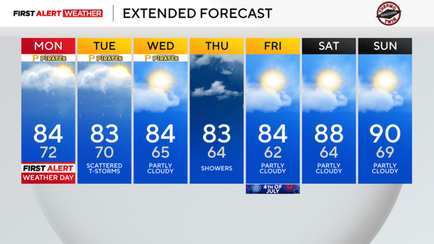
The 4th of July is looking comfy with just an isolated rain chance at this time.
Current Conditions | School Closings & Delays | Submit Your Weather Photos
Arriving to KDKA in June 2015, Ron Smiley has been giving a local and hopefully bright outlook on the day in Pittsburgh and Western Pennsylvania.